
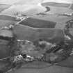
Nenthorn Old Church, Churchyard


Churchyard (Period Unassigned), Grave Slab (Medieval)
Site Name Nenthorn Old Church, Churchyard
Classification Churchyard (Period Unassigned), Grave Slab (Medieval)
Canmore ID 98526
Site Number NT63NE 4.02
NGR NT 67826 36866
NGR Description Centred NT 67826 36866
Datum OSGB36 - NGR
Permalink http://canmore.org.uk/site/98526


- Council Scottish Borders, The
- Parish Nenthorn
- Former Region Borders
- Former District Roxburgh
- Former County Berwickshire
The burial ground associated with Nenthorn Old Parish Church remained in use long after the church itself ceased to function as a place of worship. In 1930, it finally fell into disuse, with the dead being laid to rest instead in a new cemetery, located near Burnbrae Farm.
The burial ground contains a number of nineteenth-century gravestones commemorating members of the Roy family, who owned the estate of Nenthorn.
Among the earlier monuments is a memorial to a man named James Cairns. Dated 1706, it bears carved representations of a winged soul, shown with a cherub's face, and a skull and crossed longbones, a motif commonly employed on eighteenth-century gravestones as a symbol of mortality. There is also a chest tomb which has a green man motif upon one of its end slabs. The green man was a fertility symbol which is thought to have its roots in pagan times. However, it appears to have been incorporated into Christian imagery, and is often featured on seventeenth- and eighteenth-century funerary monuments.
Text prepared by RCAHMS as part of the Accessing Scotland's Past project
NT63NE 4.02 Centred 67826 36866
The church of Naithansthirn, now Nentorn, existed in the latter part of the 12th century, and in 1316 came into the possession of the monks of Kelso, who retained it until the Reformation. The foundations of the church are traceable in the centre of the churchyard.
J Robson 1896; J Ferguson 1892; G Chalmers 1810.
Portions of the south and east walls, both about 4.0m long and 0.3m high, are all that now remains of the church. The churchyard is now disused, and completely overgrown.
Visited by OS(JD) 26 May 1955.
The outline of the church cannot be determined with certainty, while the remains described by OS surveyor (JD) have more the appearance of a latter burial enclosure or vault.
Visited by OS(RDL) 15 November 1963.
Field Visit (23 October 1908)
272. Grave-slab, Nenthorn.
Situated in the graveyard, about 150 yards to the north-east of the old mansion-house of Nenthorn and about 8 feet to the east of the foundation of the east gable of the old church, is a grave-slab some 6 feet long, displaying near its upper and wider end an incised double circle with a floriated cross. Beneath the cross, and to one side, is incised a pair of shears. The stone is overgrown with moss, and its surface almost level with the ground.
See Ber. Nat. Club, 1896-98, p. 27 (illus.).
RCAHMS 1915, visited 23rd October 1908.
OS Map: Ber., xx xi. NW.
Sbc Note (15 April 2016)
Visibility: Standing structure or monument.
Information from Scottish Borders Council

