
South Uist, North Lochboisdale, Loch A' Bharp


Chambered Cairn (Neolithic), Shieling Hut(S) (Post Medieval)
Site Name South Uist, North Lochboisdale, Loch A' Bharp
Classification Chambered Cairn (Neolithic), Shieling Hut(S) (Post Medieval)
Alternative Name(s) Barp
Canmore ID 9851
Site Number NF72SE 2
NGR NF 77743 21467
Datum OSGB36 - NGR
Permalink http://canmore.org.uk/site/9851


- Council Western Isles
- Parish South Uist
- Former Region Western Isles Islands Area
- Former District Western Isles
- Former County Inverness-shire
NF72SE 2 7774 2147
(NF 7774 2147) Barp (NR)
OS 6" map, Inverness-shire, 2nd ed., (1904).
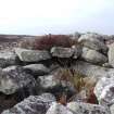
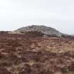
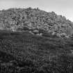
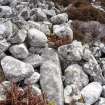
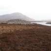
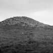
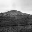
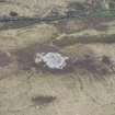
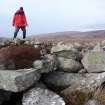
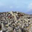
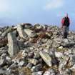
A chambered cairn at Loch a' Bharp lies on a low ridge of rock and is 19ft high, surrounded by a peristalith of upright stones, 85 to 90ft in diameter. The south side of the cairn has been robbed and disturbed and the material is spread for 30ft beyond the line of the peristalith. Traces of foundations of small buildings can be seen in this spread , which may be partly an original feature. The entrance faces east of south and the oval chamber is 7ft to the north. The south end appears to have been converted into a wheelhouse (Information from R W Feachem)
RCAHMS 1928; R W Feachem 1963; A S Henshall 1972.
The chambered cairn is as described by previous authorities. No wheelhouse is evident (Information from R W Feachem); the structures at the south end are shielings, of which about nine surround the base of the cairn.
Visited by OS (N K B), 11 May 1965.
Field Visit (19 August 1914)
Chambered Cairn, Barp, Loch a Bharp.
On a level stretch of moor about 100 yards north-west of the north-western arm of Loch a Bharp, and about 1 ¾ miles north-west of Lochboisdale, at an elevation of 50 feet above sea-level, is a barp or chambered cairn. The surface of the cairn has been much disturbed, and about 20 feet of the southern portion of the cairn has almost entirely been removed, destroying the entrance passage and exposing the chamber, which is now almost full of stones. The cairn has been almost circular, measuring about 86 feet in diameter, and it attains a height of 19 feet. It has been encircled by a number of slabs set on end round the edge at irregular intervals. Twelve of these, measuring up to 3 feet in height by 2 feet 9 inches in breadth, remain in position, seven on the westside and five on the east. (Fig. 169.)
The chamber, which is either circular or oval on plan, occupies almost the centre of the cairn. The western arc, built of large blocks of stone converging inwards towards the top, remains in position and shows a diameter of at least 12 feet; a large erect slab placed at the southern end of the arc stands 5 feet above the stones in which it is embedded, and beside it is a displaced lintel, 9 feet 3 inches long, 1 foot 10 inches broad, and 2 feet thick, while another still in position across the northern part of the chamber is 8 feet long and 1 foot 4 inches thick. Possible indications of a smaller chamber opening out of the main chamber are seen in a cavity on the west side. A considerable number of large blocks and lintel stones are scattered on the southern slope of the mound. Between the chamber and the southern edge of the cairn are three slabs set on end, apparently marking one side of the entrance passage which has measured at least 35 feet in length. The two largest slabs stand 5 feet and 4 feet above the fallen stones and measure 1 foot 2 inches and 2 feet 3 inches in breadth respectively.
RCAHMS 1928, visited 19 August 1914.
OS map: South Uist lv.
Publication Account (2007)
NF72 7 LOCH A' BHARP
NF/7774 2147
This possible wheelhouse on South Uist is located in the rubble of the Neolithic chambered cairn which gives the site its name. The south side of the cairn has been robbed and rubble is spread for 10m beyond the peristalith. Traces of a wheelhouse were observed among the stones [3] but later investigators failed to see it in 1965 [1] and noted shielings at the south end.
Sources: 1. NMRS site no. NF 72 SE 2: 2. RCAHMS 1928, 114, no. 387: 3. Feachem 1963, 60: 4. Henshall 1972, 47-9 and 520: 5. Hingley 1999, 236.
E W MacKie 2007
Field Visit (3 March 2010)
This chambered cairn forms a mound of grey stones in open heather moorland and is as described and planned by Henshall. The roof of the chamber has been removed revealing massive stone corbelling, and a huge amount of material has been robbed from the S half of the cairn. Nothing can be seen to indicate the presence of a wheelhouse, as suggested in an earlier account, except that the scale of the robbing seems greater than that required for the subrectangular shieling huts built around the S edge of the cairn.
Visited by RCAHMS (ARG,SPH) 3 March 2010

