
South Uist, Rubha Ardvule


Bothy(S) (Period Unassigned), Kelp Working Site (Post Medieval)
Site Name South Uist, Rubha Ardvule
Classification Bothy(S) (Period Unassigned), Kelp Working Site (Post Medieval)
Canmore ID 9839
Site Number NF72NW 21
NGR NF 7170 2987
Datum OSGB36 - NGR
Permalink http://canmore.org.uk/site/9839


- Council Western Isles
- Parish South Uist
- Former Region Western Isles Islands Area
- Former District Western Isles
- Former County Inverness-shire
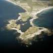
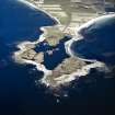
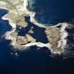
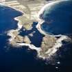
Rubha Ardvule (Rubha Aird Mhaoile) A narrow, rock-girt appendix projecting westwards from the long white sweep of the Atlantic shore. To the east of a brackish loch lie the ruins of 20 drystone kelping bothies, early 19th century shelters built for fishermen and kelp workers whose harsh existence was ruled by a cycle of seasonal work: 'The crofters and cottars remove from their homes to the shores … and live in shielings 'generally from the middle of June to the middle of August'. Each beehive-like hut has an east-facing opening, but does without lintel, door jamb and windows. Occupied fulltime by the 1870s, and still in use c.1900, their crude driftwood and turf roofs have long since disappeared.
Taken from "Western Seaboard: An Illustrated Architectural Guide", by Mary Miers, 2008. Published by the Rutland Press http://www.rias.org.uk

NF72NW 21 7170 2987.
Twenty-four contiguous single celled turf-covered structures arranged in a rectangle open to the W. Overall dimensions centred 30m by 12m.
I Shepherd, A Shepherd and C Maclean 1978.
NF 7170 2987 This site is located on the N edge of a peninsula on the W coast of South Uist (NMRS NF72NW 21; DES 1978, 34). It comprises the remains of 20 bothies which are surrounded by cultivated machair lands, although the bothies themselves are under grass which is used for grazing. The site has suffered very badly from rabbit damage, and ploughing has encroached onto the edges of some of the mounds. The entire complex was surveyed and partial excavation of two of the bothies was undertaken.
Each bothy comprised a circular mound of sand with a rectangular chamber cut into the centre. The chamber walls functioned as revetments, and were formed of gneiss cobbles pressed into the sand. Each bothy also had a narrow entrance on its E side, most of which were faced with stone along part of their length. The 1978 survey identified 24 structures, but only 20 were identified in 2000, suggesting four structures may have been lost through erosion or plough damage. Eighteen of the bothies were arranged as a group, in a rectangle open to the W, while two were located slightly to the N of the main group. All were similar in construction, although minor differences in size and design were apparent. All were partially infilled, with the exception of one that had been used as a temporary shelter in the recent past.
Excavation of the interiors and entrances of two of the bothies revealed them to be well-constructed. The entrances of both had been deliberately blocked with stones, although it was not clear whether subsequent infilling of the chambers had occurred naturally. Different phases of use were identified. A distinct floor layer of darker sand was identified in Bothy 2, and a semi-circular hearth created from several small gneiss slabs was located against the S wall. Another less formally constructed hearth was uncovered below this. Bothy 12 was a different shape from the majority, having its entrance in the SE corner rather than in the middle of the E wall. This gave a smaller internal area, and no hearth was present. No distinct floor layer was identified, but regular sweeping of the loose sand might have prevented a floor deposit from forming.
Artefacts from the bothies include ceramics (including two almost complete spongeware bowls), glass (mainly bottle glass), clay pipes, iron nails and copper-alloy boat nails. Other finds include two mother-of-pearl buttons, and a small broken glass mirror. The artefacts are still being analysed, but preliminary results suggest the site originated in the late 19th century, and use of the site continued in a sporadic fashion until the later half of the 20th century. The photograph, believed to have been taken in the early 1900s, shows the site as being occupied; the roofs of the bothies appear to have comprised a rough wooden frame, covered with turfs and other material. The entrance ways would have been low and narrow, requiring the inhabitants to stoop or crawl to enter the bothies.
The Ardvule peninsula is a particularly good area for collecting seaweed, having both N- and S-facing beaches, and it is generally assumed that the site was used by kelp makers. While kelp making is thought of as a seasonal occupation, the study of estate letter books held in the South Uist Estate Office suggests the site was occupied all year round. These documents also point to the fact that entire families were involved in this work, and this is supported by the range of material culture retrieved from the excavations. The layout of the bothies suggests some degree of organisation, and the site may have been planned by James Drever, the factor, in the early 1870s. The fact that the site appears to have been built in the later part of the 19th century is of interest, as research to date has shown that kelp production in the Western Isles declined after the 1830s. However, recent documentary work has indicated that here, at least, kelp production remained fairly strong into the later decades of the 19th century.
Sponsors: Boston University, Earthwatch.
A Badcock and J Symonds 2000

