
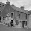
Cellardyke, Shore Street, General


General View (Period Unassigned)
Site Name Cellardyke, Shore Street, General
Classification General View (Period Unassigned)
Canmore ID 98170
Site Number NO50SE 64
NGR NO 57740 03905
NGR Description NO 57661 03823 to NO 57791 03980
Datum OSGB36 - NGR
Permalink http://canmore.org.uk/site/98170


- Council Fife
- Parish Kilrenny
- Former Region Fife
- Former District North East Fife
- Former County Fife
NO50SE 64 57661 03823 to 57791 03980
Photographic Survey (October 1963)
Photographs of buildings in Cellardyke, Fife, by the Scottish National Buildings Record/Ministry of Works in October 1963.

