
Mill Burn


Unenclosed Settlement (Prehistoric)
Site Name Mill Burn
Classification Unenclosed Settlement (Prehistoric)
Canmore ID 97937
Site Number NY29SE 76
NGR NY 2509 9022
Datum OSGB36 - NGR
Permalink http://canmore.org.uk/site/97937


- Council Dumfries And Galloway
- Parish Westerkirk
- Former Region Dumfries And Galloway
- Former District Annandale And Eskdale
- Former County Dumfries-shire
Field Visit (11 August 1993)
NY 2509 9022 NY29SE 76
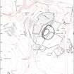
At least one ring-ditch house is situated on the leading edge of an E-facing terrace below the crest of a long ridge. It is defined by an annular ditch measuring 9m in overall diameter with traces of an external bank on the E; a gap in the bank in the NE probably indicates the position of the entrance. The W half of the house is set into the natural slope and here a ledge, up to 0.8m wide, marks the line of the outer wall. There are traces of a further two possible timber houses to the S.
Visited by RCAHMS (ARW, SPH), 11 August 1993.
Listed as timber round-house.
RCAHMS 1997.

