
Rinsary


Farmstead (Period Unassigned), Kiln Barn (Period Unassigned)
Site Name Rinsary
Classification Farmstead (Period Unassigned), Kiln Barn (Period Unassigned)
Canmore ID 97847
Site Number ND12SW 4.01
NGR ND 1168 2333
Datum OSGB36 - NGR
Permalink http://canmore.org.uk/site/97847


- Council Highland
- Parish Latheron
- Former Region Highland
- Former District Caithness
- Former County Caithness
ND12SW 4.01 1168 2333
A kiln has been built into the SW segment of the broch (ND12SW 4.00), and other structures of a depopulated settlement are adjacent to the site.
Visited by OS (J L D) 15 June 1960.
What may be a farmstead comprising one unroofed L-shaped structure is depicted on the 1st edition of the OS 6-inch map (Caithness 1877, sheet xlii). On the current edition of the OS 1:10560 map (1964), the L-shaped structure is shown conjoined to a smaller unroofed structure which is attached to the SW of the broch (ND12SW 4.00). This smaller structure may be the kiln referred to by the OS.
Information from RCAHMS (AKK) 23 November 1995.
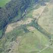
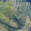
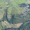
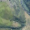
This farmstead, clustered around the remains of a broch (ND12SW 4.00), comprises two rectangular buildings linked by a bank, a kiln-barn and an enclosure. The two buildings lie to the NE of the broch. The larger building, which abuts the broch on the SW, measures 26m from NE to SW by 5m. The smaller structure, to the E, measures 12m by 4m, although it may have originally been longer. It is defined by turf-covered walls, with no stone visible, standing up to 0.4m in height. The kiln-barn is dug into the SW side of the broch to the S of which is a rectangular drystone enclosure, depicted on the 1st edition of the OS 6-inch map (Caithness 1877, sheet xlii) which measures 25m by 13m. None of the buildings are, however, depicted on the 1st edition map.
S Carter and J Rideout (Headland Archaeology) 3 March 1999; NMRS MS 899/141, no.11

