Accessibility

Font Size

100% 150% 200%

Background Colour

Default Contrast
Close Reset

Kiln Sike

Enclosure(S) (Post Medieval), Ring Enclosure (Post Medieval)

Site Name Kiln Sike

Classification Enclosure(S) (Post Medieval), Ring Enclosure (Post Medieval)

Alternative Name(s) Raeburnfoot

Canmore ID 97646

Site Number NY29NE 74

NGR NY 25357 99612

Datum OSGB36 - NGR

Permalink http://canmore.org.uk/site/97646

Ordnance Survey licence number AC0000807262. All rights reserved.
Canmore Disclaimer. © Bluesky International Limited 2025. Public Sector Viewing Terms

Toggle Aerial | View on large map

Digital Images

Raeburnfoot, oblique aerial view, taken from the NE, centred on the bank barrow. Raeburnfoot Roman Fort, and enclosures at Kiln Syke, are visible in the top left-hand corner of the photograph.
Raeburnfoot, oblique aerial view, taken from the NE, centred on the bank barrow. Raeburnfoot Roman Fort, and enclosures at Kiln Syke, are visible in the top left-hand corner of the photograph.Raeburnfoot, oblique aerial view, taken from the NNE, centred on the bank barrow. Raeburnfoot Roman Fort, and enclosures at Kiln Syke, are visible in the top left-hand corner of the photograph.,Calf Knowe, oblique aerial view, taken from the SW, centred on ring-enclosures and huts. The course of the Roman road is visible in the right half of the photograph.Raeburnfoot, oblique aerial view, taken from the N, centred on a bank barrow, with ring-enclosures, enclosures and a Roman Fort to the left of the photograph.Raeburnfoot, oblique aerial view, taken from the NE, centred on a number of ring-ditches and enclosures. The course of the Roman road is visible in the top left half of the photograph.Raeburnfoot, oblique aerial view, taken from the SW, centred on the bank barrow. Enclosures at Kiln Syke are visible in the bottom right-hand corner of the photograph.Raeburnfoot, oblique aerial view, taken from the SSW, centred on the bank barrow. Raeburnfoot Roman Fort, and enclosures at Kiln Syke, are visible in the bottom right-hand corner of the photograph.Raeburnfoot, oblique aerial view, taken from the NE, centred on the bank barrow and Raeburnfoot Roman Temporary Camp. The Reaburnfoot Roman Fort, and enclosures at Kiln Syke, are visible in the top left-hand corner of the photograph.Raeburnfoot, oblique aerial view, taken from the SW, centred on the bank barrow. Enclosures at Kiln Syke are visible in the bottom right-hand corner of the photograph.Raeburnfoot, oblique aerial view, taken from the NW, centred on the bank barrow. Raeburnfooot Roman Fort, and enclosures at Kiln Syke, are visible in the top half of the photograph.Raeburnfoot, oblique aerial view, taken from the NW, centred on the bank barrow. Enclosures and ring-enclosures are visible in the top left-hand corner of the photograph.Map of archaeological features in the landscape around Raeburnfoot. Published in Eastern Dumfriesshire: an archaeological landscape.Map of archaeological features in the landscape around Raeburnfoot. Published in Eastern Dumfriesshire: an archaeological landscape.Raeburnfoot, oblique aerial view, taken from the NE, centred on the bank barrow. Raeburnfoot Roman Fort, and enclosures at Kiln Syke, are visible in the top left-hand corner of the photograph.Raeburnfoot, oblique aerial view, taken from the NW, centred on the bank barrow. Raeburnfooot Roman Fort, and enclosures at Kiln Syke, are visible in the top half of the photograph.Raeburnfoot, oblique aerial view, taken from the NW, centred on the bank barrow. Enclosures and ring-enclosures are visible in the top half of the photograph.Raeburnfoot, oblique aerial view, taken from the WNW, centred on the bank barrow. Raeburnfoot Roman Fort, and enclosures at Kiln Syke, are visible in the top half of the photograph.Raeburnfoot, oblique aerial view, taken from the SSW, centred on the bank barrow. Raeburnfoot Roman Fort, and enclosures at Kiln Syke, are visible in the bottom right-hand corner of the photograph.Raeburnfoot, oblique aerial view, taken from the WNW, centred on the bank barrow. Raeburnfoot Roman Fort, and enclosures at Kiln Syke, are visible in the top half of the photograph.Raeburnfoot, oblique aerial view, taken from the NNW, centred on a bank barrow, with ring-enclosures, enclosures and a Roman Fort to the left of the photograph.Raeburnfoot, oblique aerial view, taken from the NW, centred on a bank barrow, with ring-enclosures, enclosures and a Roman Fort to the top of the photograph.Raeburnfoot, oblique aerial view, taken from the NW, centred on a bank barrow, with ring-enclosures, enclosures and a Roman Fort to the top of the photograph.Oblique aerial view of the Roman temporary camp, bank barrow and enclosures at RaeburnfootRaeburnfoot, oblique aerial view, taken from the N, centred on a number of ring-ditches and enclosures. The course of the Roman road is visible in the top half of the photograph.Raeburnfoot, oblique aerial view, taken from the NNE, centred on the bank barrow. Raeburnfoot Roman Fort, and enclosures at Kiln Syke, are visible in the top left-hand corner of the photograph.,Raeburnfoot, oblique aerial view, taken from the NNE, centred on a bank barrow, with ring-enclosures, enclosures and a Roman Fort to the left of the photograph.Raeburnfoot, oblique aerial view, taken from the NW, centred on the bank barrow. An enclosure and field-banks are visible in the top centre the photograph.

Administrative Areas

  • Council Dumfries And Galloway
  • Parish Eskdalemuir
  • Former Region Dumfries And Galloway
  • Former District Annandale And Eskdale
  • Former County Dumfries-shire
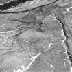
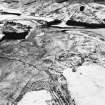
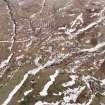
Archaeology Notes

NY29NE 74 253 996

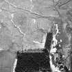
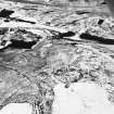
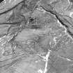
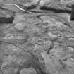
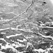
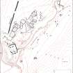
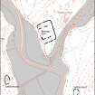
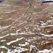
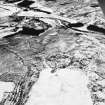
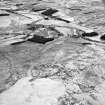
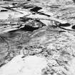
The remains of four subrectangular, turf-walled enclosures) are situated on the left bank of the Kiln Sike about 400m NE of Raeburnfoot steading (NY29NE 79). The southernmost (NY 2537 9958) is a simple structure and is open-ended to the S, but the other three (NY 2536 9962, 2535 9963 and 2534 9966) are more complex. Each of them is aligned roughly NNW to SSE with an entrance gap to the S, and in each case the W side has been extended to the S so as to form a small open-sided annexe facing ENE.

A ring-enclosure (NY 2534 9960) is situated on the opposite side of

the stream.

Visited by RCAHMS (JRS), August 1992.

References

MyCanmore Image Contributions


Contribute an Image

MyCanmore Text Contributions