
Barra, Dun Na Cille


Broch (Iron Age)(Possible), Dun (Prehistoric)(Possible)
Site Name Barra, Dun Na Cille
Classification Broch (Iron Age)(Possible), Dun (Prehistoric)(Possible)
Canmore ID 9740
Site Number NF60SW 2
NGR NF 6477 0167
Datum OSGB36 - NGR
Permalink http://canmore.org.uk/site/9740


- Council Western Isles
- Parish Barra
- Former Region Western Isles Islands Area
- Former District Western Isles
- Former County Inverness-shire
NF60SW 2 6477 0167.
(NF 6477 0167) Dun na Cille (NR)
OS 6"map, Inverness-shire, 2nd ed., (1904)
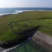
Dun na Cille: the Commission found no trace of this in 1915, but Young notes that the cemetery wall round St Brendan's Chapel (NF60SW 1) includes the base of a round tower, all that can now be traced of Dun na Cille, of massive build (which she classifies as a dun), with a square opening which gives onto the sloch below.
RCAHMS 1928.
The remains of this dun or broch comprise an amorphous mound of turf-covered stones abutting on the rounded wall at the SE corner of the graveyard. The outer face of the base of the structure can be traced on the N and W, and the SE perimeter still exists as two or three courses of massive stone blocks forming the base of the cemetery wall.
At the base of this wall (on the E side of the structure) is a small square opening, 0.7m wide, probably the original entrance.
The structure would appear to have been sub-circular, with a diameter of c 15.7m, but it was not possible to measure the width of the wall, and without excavation it is impossible to decide whether it is a broch or dun.
Surveyed at 1:10,560.
Visited by OS (W D J) 17 May 1965.
Field Visit (5 June 1915)
Dun na Cille, Borve Point.
This site lies on the shore, south of St Brendan's Chapel (NF60SW 1). No trace of the dun is to be seen.
RCAHMS 1928, visited 5 June 1915.
OS map: Barra lxiv.
Publication Account (2007)
NF60 4 DUN na CILLE
NF/6477 0167
This possible broch or dùn on Barra was not observed by the Commission [2] but later fieldwork revealed the massive blocks of part of the base of a curved stone wall at the south-east comer of the graveyard of St. Brendan's Chapel (the similarity with Toe Head is striking – NF99 1). On the east side of the structure, at the base of the wall, is a small square opening 0.7m wide which could be the original entrance [1, 3].
Sources: 1. NMRS site no. NF 60 SW 2: 2. RCAHMS 1928, 137, no. 469: 3. Young 1956, 293: 4. Branigan and Foster 2002, 84: 5. Armit 2002, 21: 6. Armit 2003, pl. 16.
E W MacKie 2007

