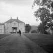
Accessibility

Font Size

100% 150% 200%

Background Colour

Default Contrast
Close Reset

Barns House

Country House (18th Century)

Site Name Barns House

Classification Country House (18th Century)

Alternative Name(s) Barns Estate

Canmore ID 96910

Site Number NT23NW 91

NGR NT 21628 39246

Datum OSGB36 - NGR

Permalink http://canmore.org.uk/site/96910

Ordnance Survey licence number AC0000807262. All rights reserved.
Canmore Disclaimer. © Bluesky International Limited 2025. Public Sector Viewing Terms

Toggle Aerial | View on large map

Digital Images

General oblique aerial view centred on Barns Tower with Barns House adjacent, taken from the SSW.
General oblique aerial view centred on Barns Tower with Barns House adjacent, taken from the SSW.View from SW.Interior.View of fireplace.Barns House, oblique aerial view, taken from the SSW.Barns House, oblique aerial view, taken from the NE.  Barns Tower is visible in the top centre of the photograph.View from EView from EGeneral oblique aerial view centred on Barns Tower with Barns House adjacent, taken from the W.General oblique aerial view centred on Barns Tower with Barns House adjacent, taken from the SSW.General oblique aerial view centred on Barns Tower with Barns House adjacent, taken from the S.General oblique aerial view centred on Barns House with Barns Tower adjacent, taken from the NNE.Distant view from NEView of River Tweed, possibly near Barns HouseView from NEView of tower and stables from SGeneral oblique aerial view centred on Barns Tower with Barns House adjacent, taken from the WSW.General oblique aerial view centred on Barns Tower with Barns House adjacent, taken from the SSE.View from EView of tower and stables from SView of River Tweed, possibly near Barns HouseView of garden wall.View from EDistant view from NEView from WView from NE.General view from SW.General oblique aerial view centred on Barns Tower with Barns House adjacent, taken from the SE.General oblique aerial view centred on Barns House with Barns Tower adjacent, taken from the NE.General oblique aerial view centred on Barns House with Barns Tower adjacent, taken from the E.View from WView of tower and stables from SView from EBarns House, oblique aerial view, taken from the SW. Barns Tower is visible in the bottom centre of the photograph.View from EView from EView from NEDistant view from NEDistant view of Barns HouseBarns House, oblique aerial view, taken from the S.Barns House, oblique aerial view, taken from the SW. Barns Tower is visible in the bottom centre of the photograph.Barns House, oblique aerial view, taken from the SSW.  Barns Tower is visible in the bottom centre of the photograph.View from EView from EView from EGeneral oblique aerial view centred on Barns Tower with Barns House adjacent, taken from the NW.View from EBarns House, oblique aerial view, taken from the E.  Barns Tower is visible in the top left-hand corner of the photograph.View from E

Administrative Areas

  • Council Scottish Borders, The
  • Parish Manor
  • Former Region Borders
  • Former District Tweeddale
  • Former County Peebles-shire

Architecture Notes

NT23NW 91.00 21628 39246

NT23NW 91.01 NT 21498 39109 Stables

NT23NW 91.02 Centred NT 21540 38912 Walled Garden

NMRS REFERENCE:

Architect: Michael Naesmyth - 1773-80 (including court of offices) - also acted as contractor (conjectural).

Activities

Photographic Record (1896)

Photograph album with views from the Scottish Borders in 1896 including Peebles

Photographic Survey (24 April 2003)

Sbc Note

Visibility: This is an upstanding building.

Information from Scottish Borders Council.

References

MyCanmore Image Contributions


Contribute an Image

MyCanmore Text Contributions