
St Kilda, Hirta, Village Bay, Cleit 70


Cleit (Post Medieval)
Site Name St Kilda, Hirta, Village Bay, Cleit 70
Classification Cleit (Post Medieval)
Canmore ID 9683
Site Number NF19NW 21.23
NGR NF 10010 99417
Datum OSGB36 - NGR
Permalink http://canmore.org.uk/site/9683


- Council Western Isles
- Parish Harris
- Former Region Western Isles Islands Area
- Former District Western Isles
- Former County Inverness-shire
NF19NW 21.23 10010 99417
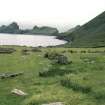
A survey was carried out by the National Trust for Scotland on over 300 cleitean (singular cleit) on St Kilda. They are double-walled, drystone-built oval or rectangular structures, used primarily for storage of food and fuel resources. Many have survived well after being abandoned in 1930 when the islands were evacuated. The survey recorded their condition, construction and location. See MS 2635 for a detailed report of cleitean and those included for detailed analysis.
M Taylor 2001
Publication Account (1988)
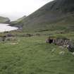
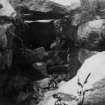
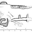
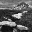
By the standards of village cleitean, Cleit 70 is small and unusual in having its entrance on a corner. Internally, it is 2.87m long by 1.37m transversely; it stands to a height of 0.91m, the floor being at least 0.3m above the level of souterrain (NF19NW 7) lintels. On the lower ground to the W several large stones form an arc around the NW corner and the SW corner is buttressed. The external walls of the cleit and a nearby stone heap on the boundary dyke contain fire-cracked stones, pounders, and a few shaped stones.
G P Stell and M Harman 1988.
Conservation (2001)
NF 101 991 (centre) As part of the Management Agreement with Historic Scotland, the monuments within Village Bay were recorded and monitored, and certain cleits, dykes and enclosures were repaired in 2001 under supervision by members of the two volunteer work parties. Detailed work included the completion of the identification of around 300 cleits for active management, and the production of a report on cleit preservation, as well as rapid assessments of coastal erosion and the deposition of builders' debris within some of the roofless structures along the village street.
Report to be deposited in the NMRS.
Photographic Survey (2002)
NF 101 991 (centre) As part of the Management Agreement with Historic Scotland, the monuments within Village Bay were recorded and monitored, and certain cleits, dykes, drains and enclosures were repaired under supervision by members of the volunteer work parties which went out to St Kilda in 2002.
A photographic survey of the coastline in Village Bay was carried out and compared to images taken in 1999. The survey indicated erosion along the NE side of the bay. Two sherds of hand-made pottery were recovered and a layer of burning noted in an exposed section.
The annual monitoring of cleits across the island was carried out and the photographic survey of them continued.
Report to be deposited in the NMRS.
Sponsors: HS, NTS.
S Bain 2002

