
St Kilda, Hirta, Village Bay, Blackhouse O


Blackhouse (19th Century)
Site Name St Kilda, Hirta, Village Bay, Blackhouse O
Classification Blackhouse (19th Century)
Canmore ID 9670
Site Number NF19NW 21.10
NGR NF 10049 99340
Datum OSGB36 - NGR
Permalink http://canmore.org.uk/site/9670


- Council Western Isles
- Parish Harris
- Former Region Western Isles Islands Area
- Former District Western Isles
- Former County Inverness-shire
Publication Account (1988)
NF19NW 21.10 10049 99340
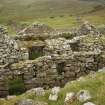
Along with Blackhouses M and N, this group of drystone buildings lies end-on to the street, occupying a site between Houses 10 and 11 in the area to the W of the main consumption dyke. Blackhouses M and N are contiguous, sharing a common side-wall. It is clear from Sharbau's plan that in 1858 these houses were used by Donald MacQueen and John Gillies. House 10 nearby, which replaced another blackhouse in this group continued to be occupied by the MacQueens, and House 11 by the Gillies household.
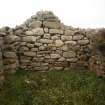
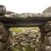
Blackhouse O measures internally 6.13m by 3.05m within walls up to 1.42m thick. Gables have been added to the end-walls which rise to a height of 3.05m. Rounded externally, the internal angles are square, and the lower halves of the NE, NW and SE angles are not mutually bonded. The N end-wall thus appears to have been partly rebuilt or refaced. Traces of red ash can be found in the interstices of this wall and at the N end of the W side-wall, while in the S gable-wall there is an area of mortared walling. A drain runs beneath this wall on to the street. The doorway, which is near the S end of the E side-wall, has a slabbed threshold and on the inner face there are two large timbers joined to form a lintel. A little to the N in the same wall the inner lintel of the window embrasure is also of timber with a stone lintel above, the window-frame itself was set about 0.41m from the inner wall-face. Traces of cement and tar on the wall-heads show the lines of the last roof and roof-timbers.
Outside a slabstone path runs between Blackhouses N and O and continues up the slope past the NE corner, possibly leading to the rubbish pit in that area.
G P Stell and M Harman 1988.

