
Pricing Change
New pricing for orders of material from this site will come into place shortly. Charges for supply of digital images, digitisation on demand, prints and licensing will be altered.
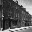
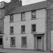
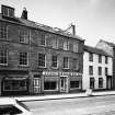
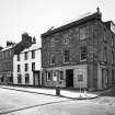
Jedburgh, 36 High Street


House (19th Century)
Site Name Jedburgh, 36 High Street
Classification House (19th Century)
Canmore ID 96552
Site Number NT62SE 123
NGR NT 65092 20705
Datum OSGB36 - NGR
Permalink http://canmore.org.uk/site/96552


- Council Scottish Borders, The
- Parish Jedburgh
- Former Region Borders
- Former District Roxburgh
- Former County Roxburghshire
NT62SE 123 65092 20705
Photographic Survey (1964)
Photographic survey of buildings in Jedburgh, Roxburghshire, by the Scottish National Buildings Record/Ministry of Work in 1964.
Sbc Note
Visibility: This is an upstanding building.
Information from Scottish Borders Council.

