
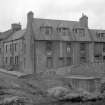
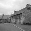
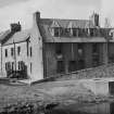
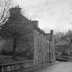
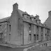
Jedburgh, Duck Row, The Piper's House


House (17th Century)
Site Name Jedburgh, Duck Row, The Piper's House
Classification House (17th Century)
Alternative Name(s) 1, 2 Duck Row
Canmore ID 96536
Site Number NT62SE 112
NGR NT 65232 20592
Datum OSGB36 - NGR
Permalink http://canmore.org.uk/site/96536


- Council Scottish Borders, The
- Parish Jedburgh
- Former Region Borders
- Former District Roxburgh
- Former County Roxburghshire
NT62SE 112 65232 20592
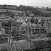
Photographic Survey (April 1962)
Photographic survey of buildings in Jedburgh, Roxburghshire, by the Scottish National Buildings Record in 1962.
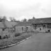
Photographic Survey (1964)
Photographic survey of buildings in Jedburgh, Roxburghshire, by the Scottish National Buildings Record/Ministry of Work in 1964.
Sbc Note
Visibility: This is an upstanding building.
Information from Scottish Borders Council.

