
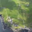
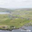
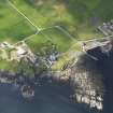
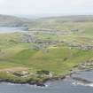
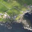
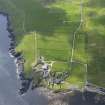
Sand Lodge


Country House (18th Century)
Site Name Sand Lodge
Classification Country House (18th Century)
Canmore ID 963
Site Number HU42SW 9
NGR HU 43667 24846
Datum OSGB36 - NGR
Permalink http://canmore.org.uk/site/963


- Council Shetland Islands
- Parish Dunrossness
- Former Region Shetland Islands Area
- Former District Shetland
- Former County Shetland
HU42SW 9.00 HU 43667 24846
HU42SW 9.01 HU 43661 24811 Walled Garden
HU42SW 9.02 HU 43672 24809 Folly
HU42SW 9.03 HU 43653 24830 Greenhouse
HU42SW 9.04 HU 43661 24838 Bow Ended Wing
HU42SW 9.05 HU 43650 24834 Smoking Room Wing
HU42SW 9.06 HU 43686 24842 West Steading
HU42SW 9.07 HU 43694 24864 North Steading
HU42SW 9.08 HU 43702 24849 East Steading
HU42SW 9.09 HU 43686 24823 Steading Cottage
HU42SW 9.10 HU 43689 24812 Garage
HU42SW 9.11 HU 43720 24829 Doocot
HU42SW 9.12 HU 43675 24896 Sundial

