Pricing Change
New pricing for orders of material from this site will come into place shortly. Charges for supply of digital images, digitisation on demand, prints and licensing will be altered.
Upcoming Maintenance
Please be advised that this website will undergo scheduled maintenance on the following dates:
Thursday, 9 January: 11:00 AM - 3:00 PM
Thursday, 23 January: 11:00 AM - 3:00 PM
Thursday, 30 January: 11:00 AM - 3:00 PM
During these times, some functionality such as image purchasing may be temporarily unavailable. We apologise for any inconvenience this may cause.
South Ronaldsay, St Margaret's Hope, Smiddybanks
Country House (Post Medieval), Heraldic Device (17th Century)
Site Name South Ronaldsay, St Margaret's Hope, Smiddybanks
Classification Country House (Post Medieval), Heraldic Device (17th Century)
Canmore ID 9613
Site Number ND49SW 10
NGR ND 4452 9387
Datum OSGB36 - NGR
Permalink http://canmore.org.uk/site/9613
- Council Orkney Islands
- Parish South Ronaldsay
- Former Region Orkney Islands Area
- Former District Orkney
- Former County Orkney
ND49SW 10 4452 9387
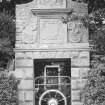
A two-storeyed mansion house, built round three sides of a square courtyard, stood on the site occupied by the farm-house of Smiddybanks. This courtyard was closed on the E side by a high wall in the centre of which was a Renaissance gateway with a 40ft deep well adjoining it. Although the house itself has disappeared, the gateway has been erected in front of the farm-house. A heraldic panel rises over the simple lintelled opening and bears a shield flanked by the dates 1633 and 1693.
D MacGibbon and T Ross 1881; RCAHMS 1946, visited 1929.
As described by the RCAHMS. The well is still in good condition inside a small outbuilding.
Visited by OS (ISS), 30 April 1973.
Field Visit (August 1997)
A two-storied mansion house once stood on the site of Smiddybank farm house. It was built around three sides of a courtyard. The fourth side was closed by a high wall, to the centre of which stood a Renaissance gateway with a 40' well adjoining it. A heraldic panel on the gateway bears a shield, flanked by the dates 1633 and 1639 (MacGibbon and Ross, 1887-92, vol. 4, 404). The gateway has been re-erected in front of the farm house and the well survives in good condition inside an outbuilding.
Moore and Wilson, 1997
Coastal Zone Assessment Survey
Orkney Smr Note
The old dwellinghouse has been entirely removed, but before it went a drawing was made of the gateway (fig 991). The house was built on a courtyard plan, with buildings on three sides and a high wall on the fourth. Mr H A Banks (proprietor) believes the house to be late 15th Century or early 16th Century, but the gateway has the dates 1633 and 1693 over it. [R1]
1688 - January 24, Kirkwall, Elizabeth Cromartie in Smithibanks, South Ronaldshay, d July 1687, David Sutherland, now of Windbreck, her oy and only executor. Disposition by deceased to Elspeth Sutherland, relict of Bernard Stewart, daughter of deceased, on January 10, 1683. c - Thomas Brown, N.P., Kirkwall.[R2]
Heraldic Panel, Smiddybanks - On this site stood a two-storeyed mansion-house built round three sides of a square courtyard. This courtyard was closed on the E side by a high wall, in the centre of which was a R enaissance gateway, with a well 40ft deep adjoining it on the inside. Although the house has disappeared, the gateway has been re-erected in front of the farmhouse. On this gateway is a heraldic panel, which is 2ft 5in
high by 2ft 3.5in wide. It bears a shield, parted per pale and charged: Dexter, a chevron and chief; sinister, three boar's heads couped and a chief, all with a bordure. Flanking the shield are the dates 1633 and 1693, with the initials DS, EC, DS, and IB. [R3]
Information from Orkney SMR [n.d.]


