
Burray, Kyelittle


Broch (Iron Age)(Possible), Mound (Period Unassigned)
Site Name Burray, Kyelittle
Classification Broch (Iron Age)(Possible), Mound (Period Unassigned)
Canmore ID 9582
Site Number ND49NE 8
NGR ND 4851 9531
Datum OSGB36 - NGR
Permalink http://canmore.org.uk/site/9582


- Council Orkney Islands
- Parish South Ronaldsay
- Former Region Orkney Islands Area
- Former District Orkney
- Former County Orkney
ND49NE 8 4851 9531.
(ND 4851 9531) Kyelittle (NR)
OS 6" map (1900)
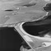
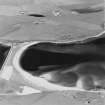
On the margin of cultivated land near the beach, are the overgrown remains of a structure of indefinite character. The mound marking tthe site rises about 5ft 6in on the N side and 8ft 6in on the S. The area is broken and uneven but only one or two smallish stones protrude through the turf. The centre iss somewhat hollowed over an area c.30ft in diameter, probably the result of some previous unrecorded investigation, and there are very slight traces of a possible wall-foundation at the N side. The remains may be either a much destroyed broch or the ruins of a chambered cairn.
RCAHMS 1946, visited 1929
This mound, still remembered as "Kyelittle", has been severely denuded since RCAHMS visit and all that survives is a roughly circular, turf-covered uneven area of ground about 20.0m in diameter, devoid of all features.
Visited by OS (IMT) 14 May 1973
'The Orcadian' reported in 1909 that this site resembled that at the nearby Hillock of Fea (ND49NE 7).
M Howe 2006
Field Visit (August 1973)
When surveyed in 1929, this site was visible as a slightly hollowed mound, some 30m in diameter. It stood up to 2m high and there were traces of a wall to the NE side. It was located on the margins of cultivated land and was thought to be the remains of a much denuded broch or chambered cairn. By 1973, all that survived was an uneven, roughly circular area of ground, c.20m in diameter and it was thought to have suffered coastal erosion. This site was not located during this survey.
Moore and Wilson, 1997
Coastal Zone Assessment Survey
Publication Account (2002)
ND49 3 KYELITTLE
ND/485953
Possible broch on Burray I., standing next to the beach at the edge of cultivated land. Only a broken and uneven mound with protruding stones is visible, and the ruins may be those of a chambered cairn [1, 2].
Sources: OS card ND 49 NE 8: 2. RCAHMS 1946 2, no. 866, 296.
E W MacKie 2002

