
Burray, West Broch Of Burray


Broch (Iron Age)(Possible)
Site Name Burray, West Broch Of Burray
Classification Broch (Iron Age)(Possible)
Alternative Name(s) Ayresdale; Northfield Battery
Canmore ID 9576
Site Number ND49NE 2
NGR ND 4847 9871
Datum OSGB36 - NGR
Permalink http://canmore.org.uk/site/9576


- Council Orkney Islands
- Parish South Ronaldsay
- Former Region Orkney Islands Area
- Former District Orkney
- Former County Orkney
ND49NE 2 4847 9871
See also ND49NE 19
(ND 4847 9871) Ayresdale (NR)
OS 6" map (1900)
A grass-covered broch known as "Ayresdale" or the "West Broch of Burray". The remains are scattered and for the most part hidden beneath the turf, but a tentative excavation carried out many years ago by Farrer revealed walls 12'6" thick and an internal diameter of 31'. A chamber was found in the thickness of the wall opening on one side into the enclosed space, and on another into a gallery which was traced nearly half way round the broch. Near the far end, the gallery communicated by a wide doorway with the interior.
RCAHMS 1946, visited 1929
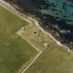
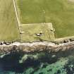
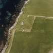
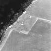
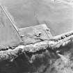
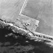
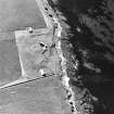
The remains of a broch surviving as a grass-covered mound of debris measuring 22.0m in diameter and 1.4m high. It has been heavily quarried from the NW, and is further mutilated by army installations. In the S arc, a curved stretch of wall 4.0m long and 0.3m high is uncertainly of the inner face or of the gallery wall.
The name "Ayresdale" is no longer known, the broch bein referred to locally simply as "the hillock".
Surveyed at 1:2500.
Visited by OS (IMT) 16 May 1973
The Orcadian newspaper mentions the excavation of the site in the mid 1850s, when a cup and comb were found (see References).
Antiquarian Observation (1862 - 1870)
Drawings by George Petrie of sites in Orkney and Shetland in sketchbook MS 28/487/7 in the Society of Antiquaries of Scotland Collection.
Field Visit (August 1997)
This site was partially excavated by Farrer, who revealed 12'6'' thick walls and an internal area of 31'. An intramural gallery and cell were also found. Today, the site appears as an amorphous mound, much disturbed by the construction of Burray Coastal Battery. It is located 20m from the coast edge, measures c.15m in diameter and stands up to 1.5m high. It is now covered with vegetation and there are no archaeological exposures or structural remains visible. The sides of the mound are pitted and the entire area appears to have been thoroughly disturbed. A number of large slabs which have been used in the construction of the battery, may derive from the broch. The mound, however, remains a substantial feature and may conceal undisturbed archaeological deposits.
Moore and Wilson, 1997
Coastal Zone Assessment Survey
Publication Account (2002)
ND49 2 BURRAY WEST (‘West Broch of Burray’, 'Ayresdale')
ND/48479871
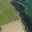
This probable ground-galleried broch stands at the foot of rolling fields sloping down to the north shore of Burray I., and about 450 m west of the East Broch (ND49 1) (visited 16/7/1963).
Little of the structure is now visible since a massive concrete gun emplacement (dating from the 1939-45 war, and covering the Churchill barrier which now joins S. Ronaldsay and Burray to the mainland), has been built next to and partly on top of it. For convenience, and as with ND29 1 above (and the three Keiss brochs in Caithness), the name of the site has been shortened here to ‘Burray West’.
The broch was partly explored in about 1860 by James Farrer and a very brief account was published by Petrie [2], with a plan and cross section prepared by Sir H. Dryden based on sketches made 1879. The broch had an internal diameter of 31 ft. (9.45 m) and a wall 12.5 ft. (3.81 m) thick. The entrance was not located -- it must have been in the uncleared half of the wall -- but a corbelled mural cell (with a narrow door to the interior at floor level) was found from which a gallery ran anti-clockwise round almost half the exposed broch wall. A wide door, lacking its lintels, led from it to the interior near the other end and the door to this was about 18 in. Above floor level., It is not clear from the Commission’s account whether this end is real or simply the limit of the part of the gallery cleared, but we now know that the latter interpretation is correct [4, 94].
The 19th century cross section shows that the lintelled gallery is about 4.5 - 5.0 ft. (1.37 - 1.53 m) high, and that the wall is standing much higher; there would have been space for an upper mural gallery, but doubtless this was not observed by Farrer because of inexperience. There appear to have been some tall sandstone slabs set upright and radially in the interior. No relics are recorded which suggests that Farrer did not clear all the internal rubble away to reach any occupation layer inside.
Dimensions: from the cross section the wall seems to have been standing about 3.66 m (12 ft.) high; from the other dimensions given the overall diameter is 56 ft.(c. 17 m), so the wall proportion works out at about 44.6%.
Sources: 1. OS card ND 49 NE 2: 2. Petrie 1890, 76, 92, 93 no. 5: 3. RCAHMS 1946, 2, no. 861, 293 and fig. 368: 4. Hedges et al. 1987, 94-5.
E W MacKie 2002
Orkney Smr Note
A little W of E Broch. Examined by Mr Farrer a few years ago. Wall about 12.5ft thick and the enclosed space 31ft diameter. Chamber found in wall, opening onto enclosure one side and a gallery the other side, which is also in wall. Gallery traced half way round wall. [R1]
Alias Ayresdale. Remains scattered, turfed over. Excavated by Farrer. Walls are 12.5ft wide, internal diameter
31ft. Chamber and gallery. [R2]
Information from Orkney SMR [n.d.]

