|
Manuscripts |
MS 1031/4 |
EASE Archaeology (Environment and Archaeology Services Edinburgh) |
Report on a Coastal Zone Assessment Survey of Orkney: Burray, Flotta, Graemsay, Hoy and South Ronaldsay. |
8/1997 |
Item Level |
|
 |
On-line Digital Images |
DP 142979 |
RCAHMS Aerial Photography Digital |
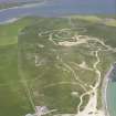
General oblique aerial view of The Bu, Burray, South Ronaldsay and Churchill Barrier No. 2, looking NNW. |
18/7/2012 |
Item Level |
|
 |
On-line Digital Images |
DP 142980 |
RCAHMS Aerial Photography Digital |
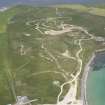
General oblique aerial view of The Bu, Burray, South Ronaldsay and Churchill Barrier No. 2, looking NNW. |
18/7/2012 |
Item Level |
|
 |
On-line Digital Images |
SC 2355516 |
Records of the Ordnance Survey, Southampton, Hampshire, England |
Burray, North Links, ND49NE 18, Ordnance Survey index card, Recto |
c. 1958 |
Item Level |
|


