
Pricing Change
New pricing for orders of material from this site will come into place shortly. Charges for supply of digital images, digitisation on demand, prints and licensing will be altered.
Upcoming Maintenance
Please be advised that this website will undergo scheduled maintenance on the following dates:
Thursday, 9 January: 11:00 AM - 3:00 PM
Thursday, 23 January: 11:00 AM - 3:00 PM
Thursday, 30 January: 11:00 AM - 3:00 PM
During these times, some functionality such as image purchasing may be temporarily unavailable. We apologise for any inconvenience this may cause.
Linlithgow, Union Canal


Canal (19th Century)
Site Name Linlithgow, Union Canal
Classification Canal (19th Century)
Alternative Name(s) Edinburgh And Glasgow Union Canal
Canmore ID 95647
Site Number NS97NE 62
NGR NS 9700 7581
NGR Description NS 9500 7751 to NS 9999 7676
Datum OSGB36 - NGR
Permalink http://canmore.org.uk/site/95647


- Council West Lothian
- Parish Linlithgow
- Former Region Lothian
- Former District West Lothian
- Former County West Lothian
NS97NE 62.00 NS 9500 7751 to NS 9999 7676.
Continued from NS97NW 61.00 and NT07NW 73.00.
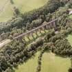
NS97NE 62.01 NS 9548 7710 Bridge
NS97NE 62.02 NS 9616 7641 Bridge
NS97NE 62.03 NS 9613 7613 Dock
NS97NE 62.04 NS 9655 7588 Milestone; Inscribed Stone
NS97NE 62.05 NS 97898 76085 Road Bridge
NS97NE 62.06 NS 9976 7650 Road Bridge
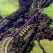
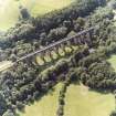
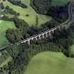
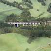
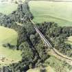
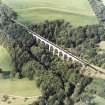
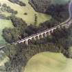
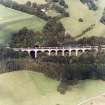
NS97NE 62.07 NS 9919 7612 Aqueduct
NS97NE 62.08 NS 97408 75822 Road Bridge
NS97NE 62.09 NS 9503 7750 Culvert
NS97NE 62.10 NS 9577 7667 Culvert
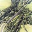
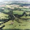
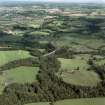
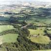
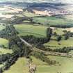
On this sheet the Union Canal continues its level course, running SE to where it crosses the River Avon (NS 967 758) before turning ENE to pass through Linlithgow.
See LIN 18 for the general record for dates and details of construction.
Information from RCAHMS (IF) March 1996
(Scheduling number 8954). The length of the [Edinburgh and Glasgow] Union Canal between the W end of Lin's Mill Aqueduct (NT17SW 47.00) and the E end of the aqueduct (NS97NE 60) over the River Avon [NS 9680 7577 to NT 1043 7063] has been accorded statutory protection by scheduling. The 20km long stretch comprises that portion of the canal within the former boundary of West Lothian.
[Extends onto NT07NW 73.00, NT07NE 57.00, NT07SE 33.00 and NT17SW 97.00].
Information from Historic Scotland, scheduling document dated 15 December 2003.
(Scheduling number 8952). The length of the [Edinburgh and Glasgow] Union Canal between the River Avon and Greenbank [NS 8648 7943 to NS 9680 7577] has been accorded statutory protection by scheduling. The 12km long stretch comprises that portion of the canal within the former boundary of Stirlingshire.
[Extends onto NS87NE 31.00 and NS97NW 61.00].
Information from Historic Scotland, scheduling document dated 15 December 2003.
Publication Account (2000)
The nineteenth century was to bring great changes to Linlithgow. One of the most important innovations was the construction of the Union Canal figure 20 from 1818 to 1822. Originally intended to link with Linlithgow Loch, the engineer, James Baird, persuaded the Union Canal Company to go ahead with a contour canal, following the course of the hillside behind the town. This obviated the need for locks, as the canal ran at the same level along the thirty-one and a half miles from Edinburgh to Falkirk. During the construction Baird stayed at the (still standing) Canal House at the Manse Basin figure 20 (seep 41); it was from here that the 'navvies', who laboured on the canal, were paid every Saturday.
Information from ‘Historic Linlithgow: The Archaeological Implications of Development’ (2000).

