
South Ronaldsay, St Mary's Church


Church (18th Century)
Site Name South Ronaldsay, St Mary's Church
Classification Church (18th Century)
Alternative Name(s) Ladykirk; South Kirk
Canmore ID 9560
Site Number ND48SW 10
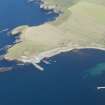
NGR ND 44006 84259
Datum OSGB36 - NGR
Permalink http://canmore.org.uk/site/9560


- Council Orkney Islands
- Parish South Ronaldsay
- Former Region Orkney Islands Area
- Former District Orkney
- Former County Orkney
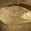
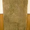
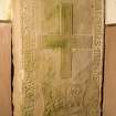
St Mary’s Church, Ladykirk Stone, Burwick, South Ronaldsay, Orkney, footprints stone
Measurements: L 1.12m, W 0.56m, D 0.23m
Stone type: whinstone
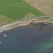
Place of discovery: ND c 4400 8425
Present location: within St Mary’s Church.
Evidence for discovery: the stone was already within the church when George Low saw and sketched it in 1774. His suggestion that it was used ‘to expose delinquents at the Church’ may indicate a secondary use for the stone and a reason for taking it into the church.
Present condition: good.
Description
This natural boulder is carved on one broad surface with two shod footprints, each 0.25m long, set side by side. It is likely to be a royal inauguration stone.
Date: early medieval.
References: Low 1879, 25, 27; Windwick 1928; RCAHMS 1946, no 841; Ritchie 1996, 125.
Compiled by A Ritchie 2017
ND48SW 10.00 44006 84259
St Mary's Church [NAT]
OS (GIS) April 2010.
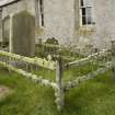
ND48SW 10.01 ND 43992 84270 Churchyard
See also ND48SW 6 and ND48SW 9.
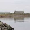
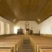
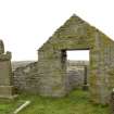
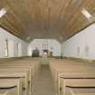
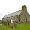
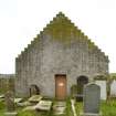
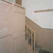
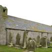
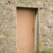
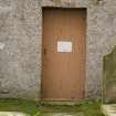
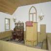
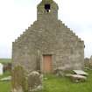
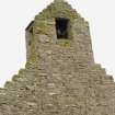
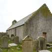
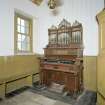
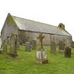
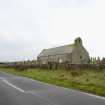
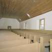
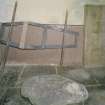
Single storey rectangular plan church with slated roof and crowstepped gables with bellcote at N end. Plain interior with memorials plaques on wall.
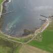
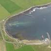
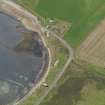
The present church (Kirk) was built around 1790. The church is depicted as roofed on the 1st Edition of the OS 6-inch map (Orkney and Shetland (Orkney) 1882, sheet cxxvi). It is described in the Object Name Book of the Ordnance Survey (ONB) as 'quoad sacra parish (a quoad sacra parish is one created and functioning for ecclesiastical purposes only). This edifice which has 413 sittings, is believed to have been originally established about the 11th century, but the exact date cannot be ascertained even the presbytory Records throw no light upon the matter. It is situated at the N side of Burwick Bay in the cnetre of the ancient burial ground of St Mary's or south Parish' (Name Book 1880).
Information from RCAHMS (DE), February 2009.
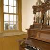
Rectangular-plan, crowstep gabled church with simple crowstepped bellcote with bell at W gable. Harled rubble; timber-framed windows; mixture of Welsh and local slate to roof. Interior recast 1896; timber pews; panelled pulpit; memorial stones.
Ecclesiastical Building in use as such. Also historically known as the Lady Kirk. A good example of a late 18th Century Orcadian parish church. According to the Old Statistical Account this church was rebuilt in about 1790. It replaced an earlier church that is marked on Blaeu's Atlas of 1654. The church houses a rounded grey whin stone that is carved with 2 footprints and is believed to be a Pictish coronation stone. (Historic Environment Scotland List Entry)
Field Visit (August 1997)
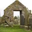
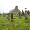
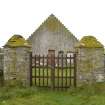
St. Mary's Church (ND48SW 10), also known as South Kirk, is said to have been established in 11th C. The present building dates to 1789, although the interior was remodelled in the late 19th C. The graveyard (ND48SW 9) contains two tombstones, dated to 1554 and 1684 respectively. The gateway to the churchyard, built c.1830, is lintelled with a gabled top. A stone, into which two footprints have been carved (ND48SW 6), is kept inside the church. It is known as the Lady Kirk stone and is likely to be a 'Pictish' artefact, of 1st millennium AD date.
Moore and Wilson, 1997
Coastal Zone Assessment Survey

