Following the launch of trove.scot in February 2025 we are now planning the retiral of some of our webservices. Canmore will be switched off on 24th June 2025. Information about the closure can be found on the HES website: Retiral of HES web services | Historic Environment Scotland
South Ronaldsay, Weems Castle
Broch (Iron Age)(Possible)
Site Name South Ronaldsay, Weems Castle
Classification Broch (Iron Age)(Possible)
Alternative Name(s) Castle Taing
Canmore ID 9546
Site Number ND48NW 2
NGR ND 4337 8885
Datum OSGB36 - NGR
Permalink http://canmore.org.uk/site/9546
- Council Orkney Islands
- Parish South Ronaldsay
- Former Region Orkney Islands Area
- Former District Orkney
- Former County Orkney
ND48NW 2 4337 8885
(ND 4337 8885) Weems Castle (NR) (Site of)
OS 6" map (1900)
The remains of a probable broch extend over an area 60' - 70' in diameter on the Castle Taing, a small headland. On the landward side the headland has been defended by two concentric walls or ramparts over 12' wide, and in places, 5' high. A modern cart-track passes through them from the NE, and this may have been the original line of approach. The remains are almost completely overgrown so that no arrangement can be traced.
G Low 1879; RCAHMS 1946, visited 1929.
"Weems Castle", undoubtedly the remains of a broch with outworks generally as described by the RCAHMS. The broch survives as a turf-coveered mutilated mound of debris c.20.0m in diameter and 1.2m high, with no trace of its foundation visible, nor of the lime mortared structure mentioned and planned by the RCAHMS. A grooved stone, 8" x 3 1/2" (possibly a net-sinker) found embedded in the outworks, is retained by Arch Div Edinburgh.
Surveyed at 1:2500.
Visited by OS (ISS), 3 May 1973.
ND 433 888 Weems Castle: broch with associated defences, prehistoric.
Sponsors: Historic Scotland, Orkney Archaeological Trust.
G Wilson and H Moore 1997.
'The Orcadian' in 1903 mentions alternative names for the castle - Lady Wemyss' Castle and St lowrie's Castle. It also states the tradition of a subterranean passage, known as a 'weem'.
M Howe 2006.
Field Visit (August 1997)
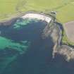
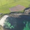
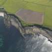
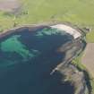
A broch mound, 20m in diameter and 1.5m high, is located on a small headland, surrounded by low cliffs. A double series of ditch and bank defences, to the landward side of the broch, frame a narrow entrance passage on the E side. The broch structure lies beneath a grass-covered mound of accumulated rubble and soil deposits. Several large stones, which may be structural, protrude from the ground surface and there are small exposures of rubble to the seaward side. The outermost defences comprise a curvilinear earthen and stone bank with a ditch to the inside. The bank is 1.5m wide and up to 1m high. The inner bank, which also has a ditch to its inside, survives to a height of 1.5m and is up to 2m wide.
Moore and Wilson, 1997
Coastal Zone Assessment Survey
Publication Account (2002)
ND48 2 WEEMS CASTLE ('Lady Weems' Castle')
ND/434889
Probable broch on South Ronaldsay, situated on a small headland known as Castle Taing. The site is clearly a defensive one since there are two concentric walls or ramparts on the east side of a large mound, the north ends finishing at a cliff; there is a steep slope down to the beach to the west of the mound [2]. A 1973 report concludes, in spite of the absence of visible masonry, that the site is that of a broch [1].
Sources: 1. OS card ND 48 NW 2: 2. RCAHMS 1946, 2, 284, no. 816 and fig. 364.
E W MacKie 2002
Note (12 February 2015 - 31 May 2016)
The angular promontory on the S side of the bay at Sandwick on the W coast of South Ronaldsay is cut off from the landward side by two ditches with external ramparts, which enclose a substantial mound that probably contains the stump of a broch. The inner rampart still stands 1.5m high, and the outer 1m high, and the mound in the interior, which has been heavily eroded along its NW and SW margins, measures about 28m from N to S by about 20m transversely, covering an area of about 0.05ha. While conventionally regarded as outworks to a broch, the relationship between these two elements is unknown.
Information from An Atlas of Hillforts of Great Britain and Ireland – 31 May 2016. Atlas of Hillforts SC2811
Orkney Smr Note
The remains of a probable broch known as Weems Castle extend over an area of from 60 to 70ft in diameter on the Castle Taing. On the landward side the headland has been defended by two concentric ramparts, which are more than 12ft wide, and 5ft high in some parts. The remains are almost completely overgrown. Such
fragmentary pieces of building as can still be observed show the use of lime mortar, and are therefore, presumably not original. Low describes it as a small rock fort....having the remains of a rampart towards the land, the dimensions very small, has been, like most others round the coast, circular, but not so much as a foundation stone remains. This description confirms that the remains are in all probability those of a broch. [R1] + [R2]
Information from Orkney SMR [n.d.]


