Accessibility

Font Size

100% 150% 200%

Background Colour

Default Contrast
Close Reset

Duns, 10 Currie Street

Terraced House (19th Century)

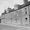
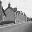
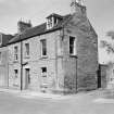
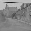
Site Name Duns, 10 Currie Street

Classification Terraced House (19th Century)

Canmore ID 95385

Site Number NT75SE 123

NGR NT 78703 53855

Datum OSGB36 - NGR

Permalink http://canmore.org.uk/site/95385

Ordnance Survey licence number AC0000807262. All rights reserved.
Canmore Disclaimer. © Bluesky International Limited 2025. Public Sector Viewing Terms

Toggle Aerial | View on large map

Digital Images

Currie Street, Duns, including view of the United Free Church
Currie Street, Duns, including view of the United Free Church9-10 Currie Street, Duns, BerwickView of 8, 9 and 10 Currie Street, Duns from westView of 8, 9 and 10 Currie Street, Duns from north westView of 9 and 10 Currie Street, Duns from south westFrom SW.View from NW.View from SW.View from W.Currie Street, Duns, including view of the United Free Church

Administrative Areas

  • Council Scottish Borders, The
  • Parish Duns
  • Former Region Borders
  • Former District Berwickshire
  • Former County Berwickshire

Activities

Photographic Survey (1962)

Photographic survey of buildings in Duns, Berwickshire, by the Scottish National Buildings Record in 1962.

Sbc Note

Visibility: This is an upstanding building.

Information from Scottish Borders Council.

References

MyCanmore Image Contributions


Contribute an Image

MyCanmore Text Contributions