Accessibility

Font Size

100% 150% 200%

Background Colour

Default Contrast
Close Reset

Pricing Change

New pricing for orders of material from this site will come into place shortly. Charges for supply of digital images, digitisation on demand, prints and licensing will be altered. 
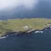
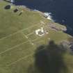
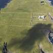
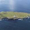
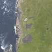
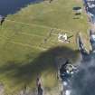
 

Muckle Skerry

Midden (Period Unassigned), Structure (Period Unassigned)

Site Name Muckle Skerry

Classification Midden (Period Unassigned), Structure (Period Unassigned)

Alternative Name(s) Pentland Skerries; Pentland Firth

Canmore ID 9510

Site Number ND47NE 6

NGR ND 464 784

Datum OSGB36 - NGR

Permalink http://canmore.org.uk/site/9510

Ordnance Survey licence number AC0000807262. All rights reserved.
Canmore Disclaimer. © Bluesky International Limited 2025. Public Sector Viewing Terms

Toggle Aerial | View on large map

Digital Images

Administrative Areas

  • Council Orkney Islands
  • Parish South Ronaldsay
  • Former Region Orkney Islands Area
  • Former District Orkney
  • Former County Orkney

Archaeology Notes

ND47NE 6 464 784.

Stone foundations and traces of kitchen midden 45yds NW of the disused lighthouse on Muckle Skerry (information from A Black, lighthouse keeper).

RCAHMS 1946

Not located, unless Black was referring to ND47NE 3.

Visited by OS (AA) 8 May 1973

References

MyCanmore Image Contributions


Contribute an Image

MyCanmore Text Contributions