
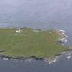
Saltwater Geo, Muckle Skerry


Broch (Iron Age)(Possible), Structure (Period Unassigned)
Site Name Saltwater Geo, Muckle Skerry
Classification Broch (Iron Age)(Possible), Structure (Period Unassigned)
Alternative Name(s) Pentland Skerries; Pentland Firth
Canmore ID 9509
Site Number ND47NE 5
NGR ND 4681 7846
Datum OSGB36 - NGR
Permalink http://canmore.org.uk/site/9509


- Council Orkney Islands
- Parish South Ronaldsay
- Former Region Orkney Islands Area
- Former District Orkney
- Former County Orkney
ND47NE 5 4681 7846.
The late Mr A Black, formerly keeper of the lighthouse on the Muckle Skerry reported that he had found a semi-circular enclosure at the head of Saltwater Geo; in his opinion, part of a broch, the remainder of which had been swept away by the sea. He did not record overall dimensions but stated that the thickness of the wall of the enclosure was 5ft to 5ft 6in. The structure is thus unlikely to be a broch not withstanding the words "Brough Geo" and "The Brough" which appear on the OS 6" map. The foundations of a straight wall could also be seen running for 60 yds. in a southerly direction from the wall of the enclosure.
RCAHMS 1946
There is no trace of this structure in the vicinity of Saltwater Geo, nor of a straight wall. There is a curving field dyke to the W of the Geo, and on the S brink at the head of rock cut steps is a curving path 1.7m wide flanked by dry-walling, somewhat reminiscent of a broch gallery, but it is doubtful if these relatively recent structures are those referred to by Black.
Visited by OS (ISS) 8 May 1973
Publication Account (2002)
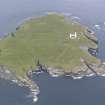
ND47 1 MUCKLE SKERRY ('Saltwater Geo')
ND/468785
Doubtful possible broch on Muckle Skerry South Ronaldsay. Stone foundations and traces of a kitchen midden were seen at several places on this small island and the ones at the site are supposed to have resembled a broch, although the wall was rather thin [3]. There is nothing to be seen now [1]. Some hand-made potsherds, together with a small-toothed, double-edged composite bone comb, were recovered and sent to the National Museum [2], but it is not clear from which site they came. The islet seem too small to have supported a broch community.
Sources: 1. OS card ND 47 NE 5: 2. Proc Soc Antiq Scot 70 (1935-36), 393 and fig. 1: 3. RCAHMS 1946, 2, 365, no. 6.
E W MacKie 2002

