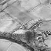
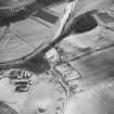
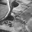
Accessibility

Font Size

100% 150% 200%

Background Colour

Default Contrast
Close Reset

Potholm

Farmhouse (Period Unassigned), Farmstead (Period Unassigned)

Site Name Potholm

Classification Farmhouse (Period Unassigned), Farmstead (Period Unassigned)

Canmore ID 94987

Site Number NY38NE 45

NGR NY 3536 8788

NGR Description From NY 3536 8788 to NY 3552 8775

Datum OSGB36 - NGR

Permalink http://canmore.org.uk/site/94987

Ordnance Survey licence number AC0000807262. All rights reserved.
Canmore Disclaimer. © Bluesky International Limited 2025. Public Sector Viewing Terms

Toggle Aerial | View on large map

Digital Images

Oblique aerial view from SE, centred on Staplegordon old parish church and Barntalloch motte-and-bailey castle. Potholm farmsteading is visible in the bottom right-hand corner of the photograph.
Oblique aerial view from SE, centred on Staplegordon old parish church and Barntalloch motte-and-bailey castle. Potholm farmsteading is visible in the bottom right-hand corner of the photograph.Oblique aerial view from NE, centred on Staplegordon old parish church and Barntalloch motte-and-bailey castle. Potholm farmsteading is visible in the bottom left-hand corner of the photograph.Oblique aerial view from NE, centred on Staplegordon old parish church and Barntalloch motte-and-bailey castle. Potholm farmsteading is visible in the bottom left-hand corner of the photograph.

Administrative Areas

  • Council Dumfries And Galloway
  • Parish Langholm
  • Former Region Dumfries And Galloway
  • Former District Annandale And Eskdale
  • Former County Dumfries-shire

Archaeology Notes

NY38NE 45 3536 8788 to 3552 8775

References

MyCanmore Image Contributions


Contribute an Image

MyCanmore Text Contributions