
Pricing Change
New pricing for orders of material from this site will come into place shortly. Charges for supply of digital images, digitisation on demand, prints and licensing will be altered.
Scheduled Maintenance Notice
Please be advised that this website will undergo scheduled maintenance starting on Thursday, 30th January at 11:00 AM and will last until Friday, 31st January at 10:00 AM.
During this time, the site and certain functions may be partially or fully unavailable. We apologise for any inconvenience this may cause.
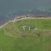
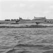
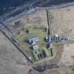
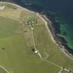
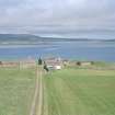
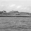
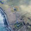
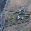
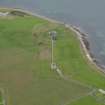
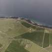
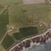
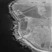
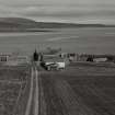
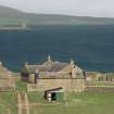
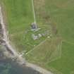
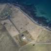
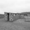
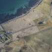
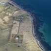
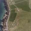
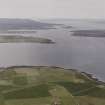
South Walls, Hackness, The Battery


Ablutions Block (19th Century), Battery (19th Century), Military Camp (19th Century)
Site Name South Walls, Hackness, The Battery
Classification Ablutions Block (19th Century), Battery (19th Century), Military Camp (19th Century)
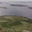
Alternative Name(s) Longhope Gun Battery; Longhope Anchorage; Scapa Flow; Lyness; South Waas
Canmore ID 9497
Site Number ND39SW 9
NGR ND 33738 91483
Datum OSGB36 - NGR
Permalink http://canmore.org.uk/site/9497


First 100 images shown. See the Collections panel (below) for a link to all digital images.
- Council Orkney Islands
- Parish Walls And Flotta
- Former Region Orkney Islands Area
- Former District Orkney
- Former County Orkney
ND39SW 9 33738 91483
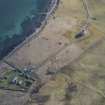
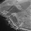
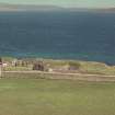
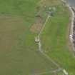
For associated Martello Towers at Hackness (ND 3384 9128) and Crockness (ND 3242 9344), see ND39SW 8 and ND39SW 10 respectively.
The Battery [NAT]
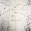
OS 1:10,000 map, 1976.
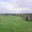
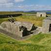
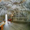
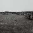
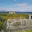
An archaeological investigation was undertaken at Hackness Gun Battery in November 1997 by Headland Archaeology Ltd. The work was commissioned by Historic Scotland who also funded the investigation. It is proposed by Historic Scotland to consolidate the site and present it to the public. The archaeological investigation was intended to provide vital information necessary to reconstruct the battery as it would have looked in 1866.
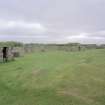
The original 1815 gun battery is largely intact and preserved although the gun platforms were almost completely destroyed by the 1866 refurbishment. The 1866 battery is intact although the racers for the guns have been removed from the excavated gun platform. Many addtional features were identified by a geophysical survey (Headland Archaeology Ltd, Geophysical report HAC97; NMRS MS/899/67, 1997).
C Moloney 1998 (Headland Archaeology Ltd); NMRS MS/899/43.
ND 337 914 An archaeological investigation, involving geophysical survey and excavation, at Longhope Gun Battery identified a well-preserved series of structures and deposits relating to the structural development of the monument. The fragmentary remains of the 1815 battery were found beneath the 1866 structure. The magazine and shifting room were fully excavated and found to be well-preserved. Although heavily robbed of stone, the gun platforms also proved to be well-preserved and limited investigation identified the 1815 rampart and part of a possible earlier gun platform. Further investigation included excavation of the surrounding perimeter ditch and investigation of the nature of the magazine drainage system. Geophysical survey, undertaken by Arkensol, identified two previously unknown structures as well as numerous service trenches of varying dates and functions.
Sponsor: Historic Scotland
C Moloney 1998
ND 337 914 Excavations continued in 1999 at Hackness Gun Battery (Moloney 1998; NMRS ND39SW 9), with work concentrating mainly on the gun platforms. Two trenches were excavated across the whole of the 1866 platform. The eight 1866 gun racer cuts were all found to have been robbed out. There was also evidence of the original gun racers that had been truncated during the later refurbishment. One area of paving relating to the 1815 period was found undisturbed in the SW corner of the gun platforms. Further work was undertaken in the magazine and a strip of the missing northern bank was reconstructed. Examination of geophysical anomalies to the E of the gun battery revealed a probable prehistoric burial cairn.
Sponsor: Historic Scotland
S Halliday 1999
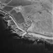
ND 3373 9149 to ND 3384 9128 The excavation of a water main trench was monitored at Hackness Gun Battery (NMRS ND39SW 9), on the island of Hoy. The trench was dug in September 2000, mostly by machine, partly by hand, and ran from the 19th-century battery (ND 3373 9149) to the Martello Tower (ND 3384 9128; NMRS ND39SW 8), a distance of some 110m.
No features were found outside the Martello Tower, except for the hard-core around the gateways, which is apparently of recent origin. The proximity of bedrock indicates that the tower was, unsurprisingly, built on solid foundations.
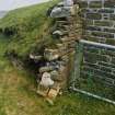
Two features in the field relate to the gun battery, the lightning conductor, and the drain immediately outside the battery wall, which may well replace an original drain. Inside the battery the layer of mortar and stone probably represents construction or demolition debris, the clay and stones below this may represent either natural subsoil, or, more likely, a redeposited dump, used as a level building platform.
A further watching brief was undertaken in May 2001 during the machine-excavation of three test trenches. No finds or features were noted.
The turf in a hand-dug trench was of very recent origin, and the rubble it overlay presumably represents building or demolition debris associated with the powder magazine. The slope to the base of this deposit probably represents the edge of the hole into which the magazine has been built, in an attempt to absorb the blast of any accidental explosion. The trenches revealed nothing of archaeological significance.
Sponsor: Historic Scotland
D Murray and G Ewart 2001
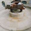
ND 3373 9149 A series of archaeological tasks were undertaken as part of ongoing development works (see DES 1999, 68-69). Various service trenches were archaeologically monitored within and around the battery compound. A detailed topographic survey of the enclosure ditch was made. Six trenches were hand-dug by archaeologists to locate and expose the original flagpole base, to further investigate the lightning conductor identified in 1997, and to excavate a section over the enclosure ditch at the point where it was to be crossed by the service trench.
An area of paving was identified outside the barracks building during the service trenching, which belonged to an early structural phase of the battery. The flagpole base was located and recorded. The lightning conductor was further exposed and the enclosure ditch was sectioned and recorded.
Full report lodged with the NMRS.
Sponsor: Historic Scotland
J Millar 2001
Orkney Smr Note (August 1987)
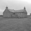
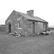
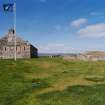
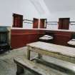
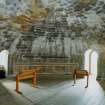
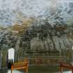
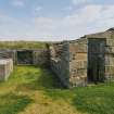
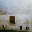
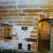
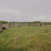
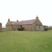
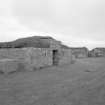
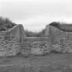
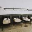
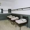
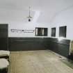
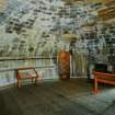
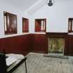
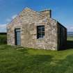
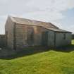
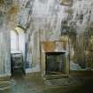
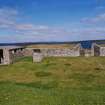
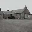
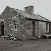
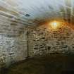
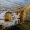
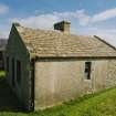
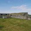
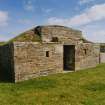
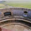
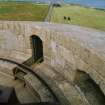
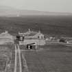
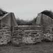
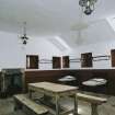
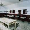
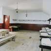
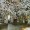
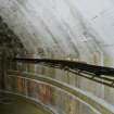
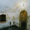
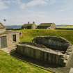
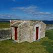
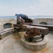
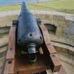
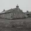
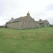
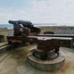
The Hackness Battery and the Martello Tower (OR 1969) together with the tower at Crockness OR 2045) were built 1813-15 to guard the convoy anchorage at Longhope against the threat of American privateers. The Battery was remodelled in 1866 to mount heavier guns, in response to fears of commerce raiding by USA-based units of the 'Fenian Navy', a threat which did not actually materialise. The guns were maintained into the 1890's by which time they were obsolete; they were finally removed about the turn of the Century. As originally constructed the Battery had eight 24-pounder guns firing over a parapet; behind was a barrack-room and underground magazine, the whole enclosed within a boundary wall. In 1866 the parapet was raised and modified to allow for 68-pounder guns to fire through embrasures. The barracks were improved, officers' quarters and a guardroom added at the entrance, and a cookhouse and ablutions block built. Apart from the magazine, the roof of which was dismantled after 1918 for the sake of its bricks, the buildings remain little altered. Mr Cload, the present owner, lives in the officers' quarters. The Battery and its buildings have been kept in excellent order, although some repairs, especiallly to the roof of the barrack-block, will be needed to prevent deterioration setting in.[R1] [R2]
Information from Orkney SMR (RGL) August 1987.
Field Visit (August 1987)
Hackness Battery ND 3373 9149 ND39SW 9
This, along with ND39SW 10 and ND39SW 8, was built in 1813-15 to guard the convoy anchorage at Longhope against American privateers, and was remodelled in response to the 'Fenian Navy' scare of 1866. Originally mounting eight 24-pounder guns en barbette, in its modified form it had four 68-pounders firing through embrasures; after 1866 the walled precinct also contained a cook house, officers' quarters and a guardroom, in addition to the original magazine and barrack-block. Apart from the removal of the guns and the dismantling of the magazine roof, these buildings remain unaltered; the present owner, who lives in the officers' quarters, has managed to preserve this outstanding mid-Victorian battery in remarkably fine condition.
RCAHMS 1989, visited August 1987.
(Fereday 1971; Ritchie 1985, 22-3; OR 2050).
Publication Account (1996)
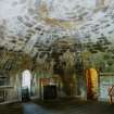
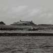
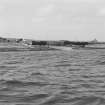
The tower appears to be circular, but the wall on the seaward side is twice as thick as that on the landward side in order to withstand bombardment,and this creates an elliptical plan. Inside, each of the floors is circular. Access into the tower is on the landward side at first-floor level, as a defensive measure; a single doorway, set at a height of about 4m above ground-level and reached originally by a portable ladder, leads into the living quarters for the gunners and their N.C.O. The tower had its own water-supply from a cistern built into the foundations, and the water could be raised to the living quarters by a hand-pump set into the recess on the left-hand side of the entrance passage. The beds were arranged radially round the wall, and the N.C.O. had the privacy of his own cubicle. Stairs within the thickness of the wall led down to the ground-level storeroom and magazine and up to the parapet and gun platform. At a height of some 10m above the ground, the top of the tower gives a wide view over the approaches to the Longhope anchorage, and the 24-pounder cannon could also guard the landward side of the battery against any attack from a landing party. The original gun mounting was modified in 1866, and the tower was used as a naval signal-post during the First World War.
Less than 180m to the north-west of the tower lies the battery, designed as a powerful deterrent with eight 24-pounder guns sweeping the south-east approaches to Longhope through Switha Sound and Cantick Sound. The gunners were protected by a stone parapet and an embankment, while behind the battery were their barracks and stores and a magazine built partially underground, the whole installation enclosed within a high stone wall on the landward side. Most important of the extensive renovations carried out in 1866 was the remodelling of the battery itself to provide heavier guns and better protection for the gunners: four 68-pounder cannons were mounted so as to fire through embrasures rather than simply over the parapet. Additional domestic buildings include, beside the gate, an officers' block which later became a farmhouse. The sandstone used to build both the Hackness and Crockness martello towers and the battery was quarried at Bring Head on the northeast coast of Hoy and transported by boat to Longhope.
Information from ‘Exploring Scotland’s Heritage: Orkney’, (1996).
Watching Brief (4 September 2000 - 7 September 2000)
Kirkdale Archaeology were asked to monitor the digging of a water main trench at Hackness gun battery, on the island of Hoy, Orkney. The trench was dug over two days, mostly by machine, partly by hand, and ran from the battery (ND 337 915) to the Martello Tower (ND 338 913), a distance of some 110m.
No features were found outside the Martello Tower, except for the hard-core around the gateways, which is apparently of recent origin. The proximity of bedrock indicates that the tower was, unsurprisingly, built on solid foundations. The layer of sand got progressively thinner as the trench progressed to the SE, and uphill, which would correspond with this being a wind blown sand deposit, decreasing with distance from the sea. The small scatter of china in the field to the N of the track probably represents low intensity agricultural practices, with the brick built drain also serving an agricultural function. Two features in the field relate to the gun battery, the lightning conductor, and the drain immediately outside the battery wall, which may well replace an original drain. Inside the battery the layer of mortar and stone probably represents construction or demolition debris, the clay and stones below this may represent either natural subsoil, or, more likely, a redeposited dump, used as a level building platform.
Sponsor: Historic Scotland
G Ewart and D Murray 2000
Kirkdale Archaeology
Excavation (May 2001)
Kirkdale Archaeology were asked to excavate a small trench, and monitor the excavation of three test trenches at Hackness, on Hoy, an early 19th-century gun battery. The trench was to be dug at the top of a set of steps leading down to the powder magazine for the installation of a concrete pad, to allow the reinstatement of the stairs. Three small, machine dug, test pits were to be excavated to the N of the battery, in order to assess the drainage potential of the area to assist the provision of toilets to the monument.
The hand dug trench inside the battery was located 105cm to the W of the top of the stairs. Apart from the slate fragments noted (but not retained) in F002, no finds were recovered.
The turf in a hand-dug trench was of very recent origin, and the rubble it overlay presumably represents building or demolition debris associated with the powder magazine. The slope to the base of this deposit probably represents the edge of the hole into which the magazine has been built, in an attempt to absorb the blast of any accidental explosion. The trenches revealed nothing of archaeological significance.
Sponsor: Historic Scotland
D Murray and G Ewart 2001
Kirkdale Archaeology
Watching Brief (23 June 2011)
ND 3376 9146 and ND 3371 9150 A watching brief was maintained on 23 June 2011 during the excavation of five small holes in advance of the installation of two new gates. The location of one of the gates was adjusted, to avoid damaging wall foundations revealed in a gap between the far W end of the 1866 earthworks and the W boundary wall (ND 33709 91496). Other trenches revealed levelling deposits and demolition/construction debris, probably associated with the 1866 remodelling of the battery, but possibly part of later landscaping.
Archive: RCAHMS (intended)
Funder: Historic Scotland
Kirkdale Archaeology, 2011

