
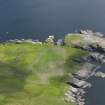
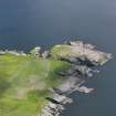
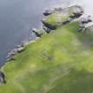
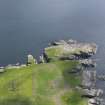
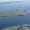
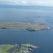
Burraland


Corn Drying Kiln (Period Unassigned), Farmstead (Period Unassigned)
Site Name Burraland
Classification Corn Drying Kiln (Period Unassigned), Farmstead (Period Unassigned)
Canmore ID 949
Site Number HU42SW 10
NGR HU 4452 2336
Datum OSGB36 - NGR
Permalink http://canmore.org.uk/site/949


- Council Shetland Islands
- Parish Dunrossness
- Former Region Shetland Islands Area
- Former District Shetland
- Former County Shetland
Note
A farmstead comprising seven roofed buildings, two partially roofed buildings, one unroofed structure and threeenclosures is depicted on the 1st edition of the OS 6-inch map (Orkney & Shetland (Shetland) 1882, sheet lxii). Three unroofed buildings and four enclosures are shown on the current edition of the OS 1:10000 map (1973).
Information from RCAHMS (SAH), 12 June 2001.

