Accessibility

Font Size

100% 150% 200%

Background Colour

Default Contrast
Close Reset

Hoy, Crockness, Martello Tower

Martello Tower (19th Century)

Site Name Hoy, Crockness, Martello Tower

Classification Martello Tower (19th Century)

Alternative Name(s) Crookness; Crock Ness; Long Hope; Lyness; Longhope Anchorage; Scapa Flow

Canmore ID 9478

Site Number ND39SW 10
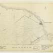
NGR ND 32426 93437

Datum OSGB36 - NGR

Permalink http://canmore.org.uk/site/9478

Ordnance Survey licence number AC0000807262. All rights reserved.
Canmore Disclaimer. © Bluesky International Limited 2025. Public Sector Viewing Terms

Toggle Aerial | View on large map

Digital Images

Hoy, Crockness, oblique aerial view, taken from the E, centred on the Martello Tower. A curving linear soilmark is visible in the top left hand corner of the photograph.
Hoy, Crockness, oblique aerial view, taken from the E, centred on the Martello Tower. A curving linear soilmark is visible in the top left hand corner of the photograph.Hoy, Crockness, oblique aerial view, taken from the SE, centred on the Martello Tower. A curving linear soilmark is visible in the centre left of the photograph.Oblique aerial view.Oblique aerial view.Oblique aerial view.Hoy, Crockness, oblique aerial view, taken from the ESE, centred on the Martello Tower. A curving linear soilmark is visible in the centre left of the photograph.Hoy, Crockness, oblique aerial view, taken from the SW, centred on the Martello Tower and a curving linear soilmark.Hoy, Crockness, oblique aerial view, taken from the ESE, centred on the Martello Tower. A curving linear soilmark is visible in the centre left of the photograph.Oblique aerial view centred on Martello tower from SW.Martello Tower, HoyMartello Tower, HoyMartello Tower, HoyMartello Tower, HoyMartello Tower, HoyMartello Tower, HoyMartello Tower, HoyMartello Tower, Crockness Orkney,Oblique aerial view.Oblique aerial view.Oblique aerial view.Hoy, Crockness, oblique aerial view, taken from the NE, centred on the Martello Tower. A curving linear soilmark is visible in the top half of the photograph.Hoy, Crockness, oblique aerial view, taken from the ESE, centred on the Martello Tower and a curving linear soilmark, and showing Rinnigill Military Camp and a crane in the background.Hoy, Crockness, oblique aerial view, taken from the NE, centred on the Martello Tower and a curving linear soilmark.Oblique aerial view centred on Martello tower from NW.Martello Tower, HoyMartello Tower, HoyMartello Tower, HoyMartello Tower, HoyMartello Tower, HoyMartello Tower, HoyMartello Tower, HoyMartello Tower, HoyMartello Tower, HoyMartello Tower, HoyMartello Tower, HoyMartello Tower, HoyMartello Tower, HoyMartello Tower, Crockness Orkney,Martello Tower, Crockness Orkney,Martello Tower, Crockness Orkney,Hoy, Crockness, oblique aerial view, taken from the NE, centred on the Martello Tower and a curving linear soilmark.Hoy, Crockness, oblique aerial view, taken from the ESE, centred on the Martello Tower and a curving linear soilmark, and showing Rinnigill Military Camp and a crane in the background.Hoy, Crockness, oblique aerial view, taken from the SE, centred on the Martello Tower. A curving linear soilmark is visible in the bottom left hand corner of the photograph.Oblique aerial view.Oblique aerial view.Oblique aerial view centred on Martello tower from W.Martello Tower, HoyMartello Tower, HoyMartello Tower, HoyMartello Tower, HoyMartello Tower, HoyMartello Tower, HoyMartello Tower, HoyMartello Tower, HoyMartello Tower, HoyMartello Tower, Crockness Orkney,Martello Tower, Crockness Orkney,Martello Tower, Crockness Orkney,Martello Tower, Crockness Orkney,Martello Tower, Crockness Orkney,Martello Tower, Crockness Orkney,Hoy, Crockness, oblique aerial view, taken from the NNW, centred on the Martello Tower. A curving linear soilmark is visible in the centre right of the photograph.Oblique aerial view.Oblique aerial view.Oblique aerial view.Hoy, Crockness, oblique aerial view, taken from the NNW, centred on the Martello Tower. A curving linear soilmark is visible in the centre right of the photograph.Hoy, Crockness, oblique aerial view, taken from the SE, centred on the Martello Tower. A curving linear soilmark is visible in the bottom left hand corner of the photograph.Hoy, Crockness, oblique aerial view, taken from the SE, centred on the Martello Tower. A curving linear soilmark is visible in the centre left of the photograph.Martello Tower, HoyMartello Tower, HoyMartello Tower, HoyMartello Tower, HoyMartello Tower, Crockness Orkney,Martello Tower, Crockness Orkney,Martello Tower, Crockness Orkney,Martello Tower, Crockness Orkney,Hoy, Crockness, Martello Tower, ND39SW 10, Ordnance Survey index card, RectoOblique aerial view of Orkney, Hoy, Crockness Martello Tower, taken from the S.  Also visible is part of the Second World War Rinnigil barrage balloon gas production plant.Hoy, Crockness, oblique aerial view, taken from the ESE, centred on the Martello Tower. A curving linear soilmark is visible in the centre left of the photograph.Hoy, Crockness, oblique aerial view, taken from the NE, centred on the Martello Tower. A curving linear soilmark is visible in the top half of the photograph.Oblique aerial view.Martello Tower, HoyMartello Tower, HoyMartello Tower, HoyMartello Tower, HoyMartello Tower, HoyMartello Tower, HoyMartello Tower, HoyMartello Tower, Crockness Orkney,Martello Tower, Crockness Orkney,Part of a map of Long Hope Sound, with remarks relating to tides and anchorages.Hoy, Crockness, oblique aerial view, taken from the SW, centred on the Martello Tower and a curving linear soilmark.View from sea to NEGuardianship plan, Martello Tower, Crockness, Hoy, OrkneyOblique aerial view of Orkney, Hoy, Crockness Martello Tower, taken from the S.  Also visible is part of the Second World War Rinnigil barrage balloon gas production plant.Martello Tower, HoyMartello Tower, HoyMartello Tower, HoyMartello Tower, HoyMartello Tower, Hoy

First 100 images shown. See the Collections panel (below) for a link to all digital images.

Administrative Areas

  • Council Orkney Islands
  • Parish Walls And Flotta
  • Former Region Orkney Islands Area
  • Former District Orkney
  • Former County Orkney

Archaeology Notes

ND39SW 10 32426 93437

Martello Tower [NAT]

OS (GIS) MasterMap, August 2010.

For (associated) Martello tower at Hackness (ND 3384 9128), see ND39SW 8.

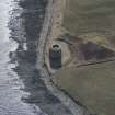
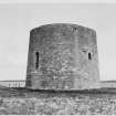
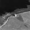
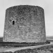
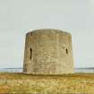
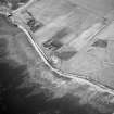
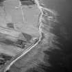
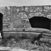
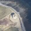
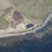
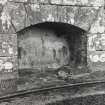
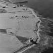
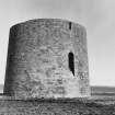
Martello Tower, Crock Ness. Built c. 1812-18.

J Gifford 1992.

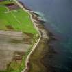
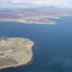
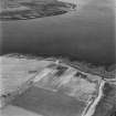
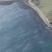
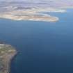
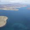
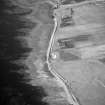
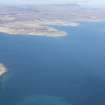
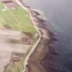
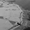
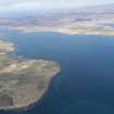
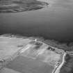
The two Martello towers at Hackness and Crockness (ND39SW 8 and ND39SW 10 respectively) were evidently constructed to cover the eastern entrance to the defended anchorage of Longhope, situated between the islands of Hoy and South Walls near the southern entrance to Scapa Flow. Their construction has traditionally been associated with the depradations of John Paul Jones.

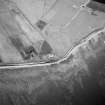
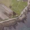
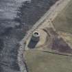
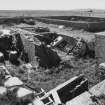
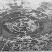
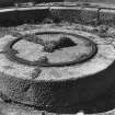
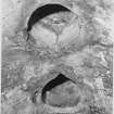
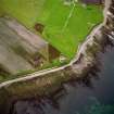
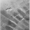
Oblique aerial photography (RCAHMSAP 1995) has recorded the circular ditch around the tower, with immediately to the S what appears to be an arc of a second, possibly earlier ditch. Within this arc is a small square structure, possibly the remains of a building which may have been a magazine. The tower was omitted from the 1st edition of the OS 6-inch map (Orkney, 1878-81, sheet cxix) 'since they were classified as of military importance' (Fereday 1971).

Information from RCAHMS (RJCM, DE), 4 and 10 September 1998.

Architecture Notes

Non-Guardiaship Sites Plan Collection, DC23158.

Activities

Note (1989)

Crockness Martello Tower ND 3242 9344 ND39SW 10

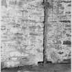
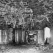
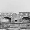
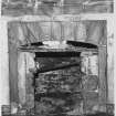
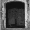
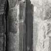
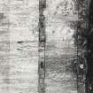
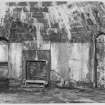
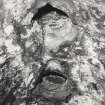
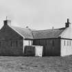
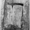
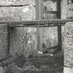
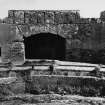
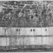
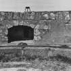
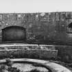
The Crockness Tower, 1813-15, is the twin of the one at Hackness (ND39SW 8), guarding the approach to the Longhope anchorage from a position on the north side of the sound. Although the tower is generally dilapidated, the masonry is still good, but the timberwork decayed.

RCAHMS 1989.

(Fereday 1971; Sutcliffe 1972, 133; OR 2045).

Field Visit (August 1997)

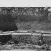
Crockness martello tower is one of two such structures which served the Hackness battery at Longhope. The battery was built in 1815, during the American War of Independence, to protect the sheltered harbourage at Longhope from American privateers.

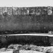
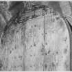
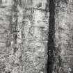
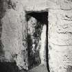
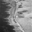
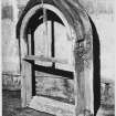
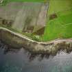
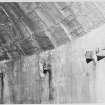
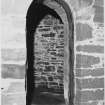
The tower is 47m in circumference and 10m high. It appears circular on the exterior, but due to a thickening of the seaward section of the wall, the interior is elliptical in plan. It was designed to be entered through a doorway on the first floor, via a removable ladder. It is not generally accessible now and thus the interior was not inspected. This site lies 1.5m from the coast edge. The coastline immediately in front of the tower is protected by a gabion wall, 20m long and 1.5m high.

Moore and Wilson, 1997

Coastal Zone Assessment Survey

References

MyCanmore Image Contributions


Contribute an Image

MyCanmore Text Contributions