
Pricing Change
New pricing for orders of material from this site will come into place shortly. Charges for supply of digital images, digitisation on demand, prints and licensing will be altered.
Huna


Midden (Viking), Settlement (Viking)(Possible)
Site Name Huna
Classification Midden (Viking), Settlement (Viking)(Possible)
Alternative Name(s) Can 035 And 036
Canmore ID 9401
Site Number ND37SE 5
NGR ND 3592 7357
Datum OSGB36 - NGR
Permalink http://canmore.org.uk/site/9401


- Council Highland
- Parish Canisbay
- Former Region Highland
- Former District Caithness
- Former County Caithness
ND37SE 5 3592 7357
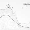
A Norse building survives as drystone walling accompanied by traces of midden in a sand mound. Walling is evident throughout the mound and the site appears to be intact although sand quarrying theatens the seaward side. Pottery was recovered. CAN 035.
A possibly Norse mound, 9.2m E-W x 4m x 0.3m high, slightly higher at the W side with a steeper scarp on the seaward side. Traces of stone within the mound suggest a structure. CAN 036.
C E Batey, Caithness Coastal Survey, 1982
Huna is identified with Hofn in Caithness where, according to the St Olaf's Saga, Hlodver, are of the Norse Earls of Orkney, was buried about 980.
J Anderson 1873.
Sand mound identified at ND 3592 7357
Visited by OS 7 May 1982.
The NGR for the Caithness Coastal Survey site CAN 036 above is given as ND 3598 7355, but it is likely from the discription that this is the mound at ND 3592 7357 (ND37SE 5).
Information from RCAHMS (FO) 17 March 1997
Project (1980 - 1982)
Field Visit (1982)
A Norse building survives as drystone walling accompanied by traces of midden in a sand mound. Walling is evident throughout the mound and the site appears to be intact although sand quarrying theatens the seaward side. Pottery was recovered. CAN 035.
A possibly Norse mound, 9.2m E-W x 4m x 0.3m high, slightly higher at the W side with a steeper scarp on the seaward side. Traces of stone within the mound suggest a structure. CAN 036.
C E Batey, Caithness Coastal Survey, 1982

