
Following the launch of trove.scot in February 2025 we are now planning the retiral of some of our webservices. Canmore will be switched off on 24th June 2025. Information about the closure can be found on the HES website: Retiral of HES web services | Historic Environment Scotland
Roberts Haven


Midden (Viking), Settlement (Viking)
Site Name Roberts Haven
Classification Midden (Viking), Settlement (Viking)
Alternative Name(s) Robertshaven; Can 041; John O' Groats
Canmore ID 9400
Site Number ND37SE 4
NGR ND 389 736
Datum OSGB36 - NGR
Permalink http://canmore.org.uk/site/9400


- Council Highland
- Parish Canisbay
- Former Region Highland
- Former District Caithness
- Former County Caithness
ND37SE 4 389 736
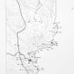
(ND 389 736) The existence of a Norse settlement is indicated by the finding of grass-bound pottery and drystone structures at Robert's Haven (PSAS 1909; OS 6" map, annotated by J Close-Brooks, NMAS, 27 April 1977).
Sherds were discovered at ND 3890 7367 in 1973-4 by R Stephen-Murray, who donated them to the National Museum of Antiquities of Scotland (NMAS) in 1977-8. Drystone structures were noted at ND 3888 7359 in 1977.
During the course of construction of a dipping tank at ND 3881 7352 further drystone structures were encountered, and a midden deposit which has eroded out in the same vicinity produced more grass-bound pottery, as well as small finds, including an anvil stone and a stone polisher, in 1981.
Yet another drystone structure is known to exist at ND 3891 7353; and above the beach at ND 3891 7361 are three mounds, 5ft in diameter and 3ft high, which are known locally as 'the lime kilns'. (nb. a tiny, unroofed, undescribed building is shown here on OS 6" map, Caithness, 1st ed., 1873.)
Exact find spots indicated by Mr Stephen-Murray (information from R Stephan-Murray to OS, 11 September 1981).
Proc Soc Antiq Scot 1980; Proc Soc Antiq Scot 1981; R Stephan-Murray 1981; Information contained in letters from R Stephan-Murray to OS, 22 June and 28 August 1981.
(ND 3891 7363) A Norse site, extending along about 40m of the coast, bisected by a seasonal stream. One drystone structure was discernible, with extensive eroding midden deposits from which came numerous pottery sherds.
C E Batey, Caithness Coastal Survey, 1982
Immediately above the foreshore at Robert's Haven there are two small areas of clearly evident settlement. The first is at ND 3876 7348, immediately N of the sheep pens, where erosion has revealed traces of midden material and walling. The second area, at ND 3890 7358, is as described and illustrated by Batey.
The mounds noted at ND 3891 7361 were not certainly identified; mounds occuring about 80m N of the second settlement may be the ones referred to. They are small, sandy and turf-covered; whether they are entirely natural or covering a structure cannot be determined.
Visited by OS (J B), 7 May 1982.
ND 387 735. Pottery and iron objects of medieval and later date from Robert's Haven, John o' Groats, were donated to the NMAS by R Stephan-Murray in 1981-2.
NMAS 1982.
In June of 1992 an archaeological sampling project began at Robert's Haven. The site was surveyed and three sample columns were excavated for detailed palaeoeconomic and environmental study. Augering was conducted along two transects to assess the survival of archaeological deposits between the wave cut bank and the ruined structure mentioned above. This intervening space, now gently sloping pasture, was extensively quarried for sand during the 1940s and 1950s (M Houston, pers comm).
Work at the wave cut bank focused on the SW midden, a 25m long, c1m thick, deposit composed of thin lenses of fish bone and shell. Two 2m sections of the midden were cleaned and drawn. A sample column 50cm by c75cm was then excavated within each of these 2m sections (columns A and B). All excavated material was retained for fine mesh seiving and soil analysis. The midden is tentatively dated to the 13th or 14th century on the basis of pottery (R Will, per comm).
The SW midden deposits showed signs of rapid accumulation and little post-depositional disturbance. Entire fish fins and even patches of articulated scales remained intact. Articulated fish bones, particularly clusters of anterior vertebrae (those close to the head), were present in 15 of 32 excavated contexts.
Fish bone dominates the excavated bone assemblage (9.3427kg, 97.9%). Preliminary examination suggests that cod (Gadus Morhua), ling (Molva molva) and saithe (Pollachius virens) are the most common species.
Shell was also very plentiful (9.0215kg). Mammal and bird bone are minor components of the deposit (approximately 0.17kg and 0.03kg respectively). The mammal bone consists of small fragments, many of which were burnt.
It is possible that the SW midden represents waste from a semi-specialized fish processing station. However, a thorough consideration of site formation processes is necessary before confirming this hypothesis. Domestic rubbish, including pottery and carbonised cereal grain, is also ubiquitous in the midden.
The auger transects failed to reveal cultural material between the 'islands' of surviving archaeology at the shore and surrounding the ruined structure (ND37SE 15). Past sand quarrying has probably removed any deposits which might once have existed. It is possible, however, that other archaeological 'islands' exist which were missed by the 20m augering interval employed in this study.
Post-excavation analyses of samples from Robert's Haven will continue into 1993. Possible future sampling will broaden in focus and investigate structural remains. Stone built rectilinear foundations are eroding from the wave cut bank. These vanishing features require attention.
J H Barrett 1992.
In 1993, three 50cm by c.75cm columns were excavated from two areas of coastal middens and palaeosols rich in fish bone and shall. These deposits may represent a fish-processing station.
J H Barrett 1993.

