
Stroma, Bught O' Camm


Promontory Fort (Period Unassigned)
Site Name Stroma, Bught O' Camm
Classification Promontory Fort (Period Unassigned)
Canmore ID 9374
Site Number ND37NW 6
NGR ND 3498 7855
Datum OSGB36 - NGR
Permalink http://canmore.org.uk/site/9374


- Council Highland
- Parish Canisbay
- Former Region Highland
- Former District Caithness
- Former County Caithness
ND37NW 6 3498 7855.
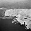
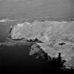
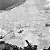
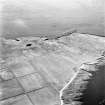
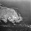
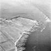
Fortified promontory on W side of Stroma island.
Information from E McGillivary, Librarian, Kirkwall, Orkney to OS, 1 May 1973.
ND 3498 7855. A fort consisting of an earth and stone rampart blocking off the sheer-sided, level-topped promontory of Bught o' Camm to enclose an area some 70.0m N-S by 30.0m transversely. The rampart stands 1.0m high on the landward side and has an average spread of 6.0m. Towards the W end, stripping of the inside of the rampart has revealed slab-facing; at this point a width of 2.3m can be estimated. In from the E end is a 3.0m gap that may be an original entrance, but could be a later break. To the E of the gap, the rampart has been partially quarried away. There is no evidence of any structures within the fort. An early-modern drain follows the outside edge of the rampart to veer away towards the W.
Revised at 1:2500.
Visited by OS (J M) 8 July 1982.
Note (19 February 2015 - 18 May 2016)
A sheer-sided promontory on the cliffs forming the W coast of Stroma has been cut off on the S by a single wall reduced to a bank some 6m in thickness by 1m in height; erosion at the W end had revealed the inner face of the wall in 1982 when it was surveyed by the OS, who estimated that the wall was about 2.3m thick at this point. A gap near the E end may mark the position of the entrance. The interior, which is roughly triangular on plan, measures about 65m from N to S by 60m transversely immediately to the rear of the wall; it is featureless.
Information from An Atlas of Hillforts of Great Britain and Ireland – 18 May 2016. Atlas of Hillforts SC2834

