
Following the launch of trove.scot in February 2025 we are now planning the retiral of some of our webservices. Canmore will be switched off on 24th June 2025. Information about the closure can be found on the HES website: Retiral of HES web services | Historic Environment Scotland
Keiss


Building(S) (Period Unassigned)
Site Name Keiss
Classification Building(S) (Period Unassigned)
Alternative Name(s) Wic 104
Canmore ID 9315
Site Number ND36SE 17
NGR ND 3529 6102
Datum OSGB36 - NGR
Permalink http://canmore.org.uk/site/9315


- Council Highland
- Parish Wick
- Former Region Highland
- Former District Caithness
- Former County Caithness
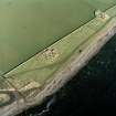
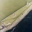
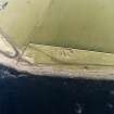
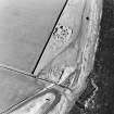
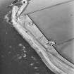
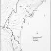
ND36SE 17 3529 6102.
A group of possibly modern conjoined structures 19m NE-SW, 20m NW-SE and 0.75m in maximum height.
C E Batey 1981.
Project (1980 - 1982)
Field Visit (1981)
A group of possibly modern conjoined structures 19m NE-SW, 20m NW-SE and 0.75m in maximum height.
C E Batey 1981.

