Accessibility

Font Size

100% 150% 200%

Background Colour

Default Contrast
Close Reset

East Haven Airfield, Royal Naval Air Station

Airfield (20th Century)

Site Name East Haven Airfield, Royal Naval Air Station

Classification Airfield (20th Century)

Alternative Name(s) Hms Peewit

Canmore ID 93089

Site Number NO53NE 59

NGR NO 5971 3755

NGR Description Centred NO 5971 3755

Datum OSGB36 - NGR

Permalink http://canmore.org.uk/site/93089

Ordnance Survey licence number AC0000807262. All rights reserved.
Canmore Disclaimer. © Bluesky International Limited 2025. Public Sector Viewing Terms

Toggle Aerial | View on large map

Digital Images

Oblique aerial view centred on the cropmarks of the airfield, taken from the SSW.
Oblique aerial view centred on the cropmarks of the airfield, taken from the SSW.General oblique view of the airfield, taken from the NE.Oblique aerial view.Oblique aerial view.East Haven Airfield, oblique aerial view, taken from the SE, centred on the airfield.General oblique view of the airfield, taken from the W.Aerial view.Oblique aerial view.Oblique aerial view.Oblique aerial view.Inverpeffer and East Haven Airfield, oblique aerial view, taken from the E, centred on various linear cropmarks. A possible rectilinear enclosure is visible in the bottom left-hand corner of the photograph, and a disused runway runs across the top half.East Haven Airfield, oblique aerial view, taken from the S, centred on the airfield.East Haven Airfield, oblique aerial view, taken from the NW, centred on the airfield.General oblique view of the airfield, taken from the NNE.General oblique view of the airfield, taken from the NNE.Oblique aerial view.Oblique aerial view.East Haven Airfield, oblique aerial view, taken from the NE, centred on the airfield.Oblique aerial view centred on the cropmarks of the airfield, taken from the NE.General oblique aerial view of the airfield, taken from the NNW.Oblique aerial view of the cropmarks of the buildings at the former airfield, looking to the SSE.Oblique aerial view.Oblique aerial view.East Haven Airfield, oblique aerial view, taken from the SE, centred on the airfield.Oblique aerial view centred on the cropmarks of the airfield, taken from the ESE.Inverpeffer and East Haven Airfield, oblique aerial view, taken from the NNE, centred on various linear cropmarks. Cropmarks of a possible rectilinear enclosure and rig are visible in the centre left of the photograph, and a disused runway runs up the right half.East Haven Airfield, oblique aerial view, taken from the S, centred on the airfield.East Haven Airfield, oblique aerial view, taken from the SEE, centred on the airfield.East Haven Airfield, oblique aerial view, taken from the NW, centred on the airfield.General oblique aerial view of the airfield, taken from the NW.Oblique aerial view.Oblique aerial view.East Haven Airfield, oblique aerial view, taken from the E, centred on the airfield.East Haven Airfield, oblique aerial view, taken from the NW, centred on the airfield.General oblique view of the airfield, taken from the SW.Oblique aerial view.Oblique aerial view.Oblique aerial view.East Haven Airfield, oblique aerial view, taken from the NE, centred on the airfield.General oblique view of the airfield, taken from the NE.General oblique view of the airfield, taken from the WNW.Oblique aerial view.East Haven Airfield, oblique aerial view, taken from the SSW, centred on the airfield.East Haven Airfield, oblique aerial view, taken from the SEE, centred on the airfield.East Haven Airfield, oblique aerial view, taken from the NW, centred on the airfield.

Administrative Areas

  • Council Angus
  • Parish Panbride
  • Former Region Tayside
  • Former District Angus
  • Former County Angus

Archaeology Notes

NO53NE 59.00 Centred 5971 3855

NO53NE 59.01 centred NO 5784 3877 Military Camp

NO53NE 59.02 NO 58783 37181 Operations block

NO53NE 59.03 centred NO 59133 37197 Aircraft Hangars; Buildings; Huts

NO53NE 59.04 centred NO 5889 3785 Aircraft Hangars; Huts

NO53NE 59.05 centred NO 5985 3804 Aircraft Hangars; Huts

NO53NE 59.06 centred NO 5880 3895 Military Camp

NO53NE 59.07 centred NO 5810 3700 Military Camp

NO53NE 59.08 NO 5912 3778 Control Tower (site of)

NO63NW 35 centred NO 6045 3791 Bomb Store

The air station was commissioned as HMS Peewit on May 1 1943 and closed in July 1946.

D J Smith 1983

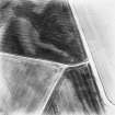
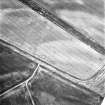
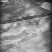
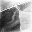
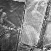
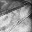
The perimeter of the airfield has been recorded on aerial photographs taken during the 1994 sortie (RCAHMSAP 1994).

Information from RCAHMS (JH) 20 January 1998.

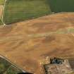
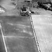
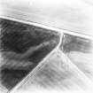
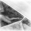
The airfield is situated N of East Haven between the A 92 Trunk Road and the coast. Many buildings are still extant along with the runways.

J Guy 2000; NMRS MS 810/9

East Haven airfield was used during World War II for Deck Landing Control Ofiicers.

B Lavery 2004

The complete area covered by East Haven airfield, including the dispersed accommodation camps is visible on a series of vertical air photographs (CPE/Scot/UK 218, 3201-3207; 4201-4209, flown 25 June 1947).

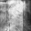
The airfield takes up an area of about 119.57 hectares, whilst the three dispersed accommodation camps NO53NE 59.01, NO53NE 59.06, NO53NE 59.07 (9.70, 7.39 and 4.02 hectares respectively), a total of 21.11 hectares. There were originally three runways, a NE-SW, W to E and NW to SE (about 1103m, 917m and 874m long respectively), though evidence from the 1988 series of air photographs and OS maps would suggest that the two shorter runways have been now reduced in length by ploughing.

The aircraft hangars are dispersed in three areas, the main group being to the NW of the runways with two other groups on the NE and SW sides. The main group of hangars to the NW (NO53NE 59.03) of the demolished control tower (NO53NE 59.08), consisted of ten 'Mainhill' or 'S' type Naval aircraft sheds set within earth blast banks with a further two 'T' or Bellman types. The group on the E side of the airfield consisted of at least twelve 'Mainhill' or 'S' type aircraft hangars, most set within earth blast banks. The group on the W side, located between Hatton House and Hatton Farm, consisted of five 'Mainhill' or 'S' type aircraft hangars, four of which were within earth blast banks. Of this group, four survive.

Three dispersed accommodation camps are also visible on the air photographs (NO53NE 59.01, NO53NE 59.06, NO53NE 59.07 ), though little survives of any of them .

Information from RCAHMS (DE), October 2005

References

MyCanmore Image Contributions


Contribute an Image

MyCanmore Text Contributions