
Scatsta Airfield


Airfield (20th Century)
Site Name Scatsta Airfield
Classification Airfield (20th Century)
Canmore ID 93073
Site Number HU37SE 15
NGR HU 3920 7255
NGR Description Centred HU 3920 7255
Datum OSGB36 - NGR
Permalink http://canmore.org.uk/site/93073


- Council Shetland Islands
- Parish Delting
- Former Region Shetland Islands Area
- Former District Shetland
- Former County Shetland
HU37SE 15.00 centred 3920 7255
HU37SE 15.01 HU 3834 7220 Anti-Aircraft Battery
HU37SE 15.02 HU 39186 72376 Aircraft Hangar
For nearby aircraft wreck (in Sullom Voe), see HU37SE 8001.
HU 385 725. The most northerly airfield in the British Isles was built to cover for lack of a fighter station in the Shetlands. One runway was resurfaced and the control tower built on the old north-south strip.
D J Smith 1983
All runways are still extant with one still in use. Other buildings survive, including the battle HQ and fuel tanks.
J Guy 1995; NMRS MS 810/4, 48-52
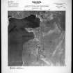
The airfield is visible on vertical air photographs (CPE/Scot/UK 285, 4428, 4430, 4477 and 4481, flown 28 August 1947), which show the airfield installations at almost their full extent.
Visible are the two runways, a single type T1 aircraft hangar, the bases and taxiways for two proposed hangars, huts and hut bases. A watch or control tower has not been identified from the air photographs, as has the Battle HQ noted by Guy .
It is known that many of the personnel for the airfield would have been accommodated at the Graven, Laxobigging camp (HU47SW 8.00) site.
The site is still in use today by the oil industry, though the NW-SE 13/31 runway is now occupied by a new control tower, terminal buildings and what is annotated as a 'coastguard station' on the Ordnance Survey maps. The coastguard station was/is a United States Coast Guard 'Loran' station built in 1968. The main NE-SW 07/31 runway was partly re-surfaced and widened during 1977 (now realigned 06/24).
Most of the associated structures, huts and the aircraft hangar have been removed, though many of the hut bases can still be seen at c.HU 3903 7227.
Visited by RCAHMS (DE, GL), Ocotber 1998

