
Freswick Links


Broch (Iron Age)(Possible)
Site Name Freswick Links
Classification Broch (Iron Age)(Possible)
Alternative Name(s) Sands, Can 060
Canmore ID 9299
Site Number ND36NE 5
NGR ND 3761 6761
Datum OSGB36 - NGR
Permalink http://canmore.org.uk/site/9299


- Council Highland
- Parish Canisbay
- Former Region Highland
- Former District Caithness
- Former County Caithness
ND36NE 5 3761 6761.
(ND 3761 6761) Broch (NR) (remains of)
OS 1:10,000 map, (1975)
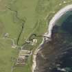
The remains of a 2nd - 3rd century broch founded on pure sand among the sandhills of Freswick Bay and now pratically obscured by sand and debris.
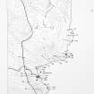
Excavated by Sir Francis Tress Barry between 1890 and 1900, it measures 32ft 8ins in diameter within a wall, 11ft 6ins thick, which has a scarcement and two mural cells. The wall is generally 7ft high 'but is partly broken down on the side towards the land, where the original entrance probably was. Facing to NE is an entrance passage by the foot of the stair, of which fourteen steps still remain. It goes up to the left from the middle of the entrance passage. . . Two curved walls of secondary construction divide the interior area of the broch into segments.' Finds include a cup-marked stone, which was in front of John Nicolson's house at Nybster (ND 36 63) in 1910. The RCAHMS include a plan, presumably based on Sir Francis Tress Barry's excavation plan, but apparently inverted as compared with Anderson's description, so that the entrance with the stair is in the SW instead of the NE. This plan also shows outbuildings attached to the W side of the broch.
J Anderson 1901; RCAHMS 1911, visited 1910; A Young 1964.
The broch is now obscured by sand, debris and a later building attached to its N side, but survives in the form of several short stretches of internal and external walling, 0.3m high on the N, E and S sides. Along the E side of the outer wall, two short sections of walling which may belong to an outbuilding may be traced.
Resurveyed at 1:2500.
The cup-marked stone is now part of an exhibition in the old schoolhouse at Nybster (ND 3682 6368).
Visited by OS (R D) 9 September 1965.
The very obscure remains of the broch are generally as described by the previous authorities. The 'later building' noted by the previous field investigator is the outbuilding illustrated by the RCAHMS, whose plan is approximately 60 W of N incorrect in orientation. Recent back-filled excavation by Batey (C Batey, Durham University) has taken place here.
A cup-marked stone with six or seven cups on it at Summerbank House (ND 3684 6361) is possibly that found at the broch.
Visited by OS (J B) 12 July 1982.
Project (1980 - 1982)
Publication Account (2007)
4 FRESWICK LINKS ('Freswick Sands', 'Sands Broch')
ND/3761 6761
Site of a probable solid-based broch in Canisbay, Caithness. It used to stand among the sandhills half a mile north of Freswick House and was excavated by Sir F Tress Barry in 1898 and described by Anderson [2]. Already in “a ruinous condition” in 1910 [3] it is now almost completely destroyed and the site is difficult to locate [8]. A plan by John Nicholson was published by the Commission [3] and shows that this site too had two entrances as well as some outbuildings. The north point is clearly reversed in the Commission's plan. The site lies half a mile north of Freswick House which can be seen in the background, with the sea and the cliffs to the left. The photographer was therefore facing south and along the stair in the direction of its rising; on the plan it rises towards the north. There is a later, Viking settlement nearby [5, 6].
Description
The building was full of sand and apparently rested on pure sand, which raises doubts as to whether it could ever have been a tall tower. One of the entrances was on the south-west and no door-checks or bar-holes are shown. A second entrance at the foot of the stair is on the north-east and no door-checks are shown here either.
If one can apply the sequence of alterations inferred for Yarrows (ND34 17) and Keiss South (ND36 6) to this site, the north-east doorway seems highly likely to be a secondary passage pushed through the thin outer part of the wall as an extension of the doorway to the mural stair. Also this passage leads on into the outbuildings and a chamber opens off its left side just outside the broch wall proper. The contemporary photograph shows the stairway, the doorway leading to it and the doorway of the mural cell beyond, but does not shed any light on the outer part of the passage here. The stairway rises to the right and 14 steps remained; there is a guard cell on the right side of the passage which should originally have been a stair-foot guard cell.
Assuming that the south-west entrance is the original one (despite the apparent absence of a door-frame) the stair doorway would be at 12 o'clock; there is an oval mural cell at 7 o'clock and another at 3 o'clock. The doorway to the latter seems to have been blocked off by the secondary facing but this is not clearly apparent in the photograph. Indeed there one can see what might be a low wall extending the far side of the cell doorway into the interior. The quality of the structural evidence from this site is too low for a proper interpretation of these features.
On excavation the broch wall was found to be 2.13m (7ft) high and a "scarcement 12 to 18ins. wide" is described as being on the interior wallface; however in 1910 this term was usually employed to describe a secondary interior wallface and there appears to be such a thing shown on the plan from 2 to 6 o'clock. There are other presumably secondary divisional walls in the interior and traces of presumably outbuildings abutting against the broch on the east side.
Discussion
Judging from the composite bone comb and the hipped bone pin (below) this broch was occupied over a long period, both in the middle and in the late Iron Age, but the exploration of the interior was so crude that no evidence survives of superimposed floor levels, as it did at Burrian broch in North Ronaldsay (HY75 1). Like many another it appears to have been modified – perhaps partly demolished – in the later stages of the middle Iron Age and as part of these changes a second doorway was pushed through the wall at the base of the stair. Presumably the various chambers outside the wall on the west side were built at this time. The absence of Viking artifacts suggests that the broch was abandoned and filling with sand when the Norsemen settled nearby.
Finds [7]
Bronze objects included a thin flat fragment with 3 rivet holes.
Bone objects included 2 decorated ball-headed pins, one hipped, the socketed spherical head for an iron pin, 1 needle, 2 awls, a cylindrical object notched at both ends, half a whorl and 2 composite, riveted, double-edged combs with 4 fragments of others.
Stone implements included 2 decorated whorls, 1 grooved weight and a stone with 9 cup-marks on it. (RCAHMS 1911b, 187, no. 576)
Glass. Young mentions a small yellow glass ring bead [4, 183] but it is not clear on what evidence the statement is based; the find is not mentioned anywhere else.
The following are mentioned only by Anderson – 1 crude sandstone vessel and some fragments, and 1 or 2 querns.
Dimensions: wall thickness 3.51m (11ft 6in) (assuming the “scarcement” to be a secondary wallface), internal diameter 9.96m (32ft 8in), overall diameter therefore c. 17m (56ft) and the wall proportion would be about 41%, relatively low.
Sources: 1. O.S. card ND 36 NE 5: 2. Anderson 1901, 143-4: 3. RCAHMS 1911b, 14-15, no. 34 and fig. 6: 4. Young 1962, 183: 5. Curle 1939: 6. Childe 1943: 7. Proc Soc Antiq Scot 43 (1908-09), 16 (finds): 8. Swanson (ms) 1985, 560-61: 9. Caulfield 1978, 132, no. 26: 10. Batey 2002, 187.
E W MacKie 2007

