
Throsk, Bandeath, Royal Naval Armament Depot


Armament Depot(S) (20th Century), Armament Depot (Second World War), Armament Depot (First World War)
Site Name Throsk, Bandeath, Royal Naval Armament Depot
Classification Armament Depot(S) (20th Century), Armament Depot (Second World War), Armament Depot (First World War)
Alternative Name(s) Rnad Throsk; River Forth; Bandeath Industrial Estate
Canmore ID 92933
Site Number NS89SE 76
NGR NS 850 928
NGR Description Centred NS 850 928
Datum OSGB36 - NGR
Permalink http://canmore.org.uk/site/92933


- Council Stirling
- Parish St Ninians
- Former Region Central
- Former District Stirling
- Former County Stirlingshire
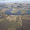
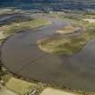
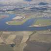
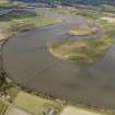
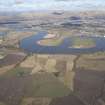
The Bandeath Munitions Depot was established in the First World War. The layout of the site and its railway (on which the munitions were delivered) are not clear, as, for security reasons, the Ordnance Survey maintained the polite fiction until well into the 1950s that the site was still open farmland. The munitions were stored in a large number of widely-separated warehouses (some 37 are still visible on modern aerial photographs) until needed, when they were loaded onto small ships for transhipment to naval vessels further down the river or at sea.
The railway branch line ran to the site from the Larbert to Alloa line at Throsk, where it crossed the river to link with the lines runing W to E towards the naval installations at Rosyth and Crombie. The railway bridge could open to allow these ships to pass up the river to Bandeath.
Many buildings survive on the site, as does the Admiralty pier and crane.
Information from HS/RCAHMS World War One Audit Project (GJB) 3 October 2013.
NS89SE 76.00 centred 850 928
NS89SE 76.01 centred NS 85002 91775 Warehouses
NS89SE 76.02 From NS 84911 93233 to NS 85537 93010 Ammunition Storage huts
NS89SE 76.03 From NS 84874 93126 to NS 85502 92903 Ammunition Storage huts
NS89SE 76.04 From NS 84838 93022 to NS 85462 92800 Ammunition Storage huts
NS89SE 76.05 From NS 84903 92881 to NS 85426 92696 Ammunition Storage huts
NS89SE 76.06 From NS 84972 92738 to NS 85338 92590 Ammunition Storage huts
NS89SE 76.07 From NS 84934 92633 to NS 85248 92520 Ammunition Storage huts
NS89SE 76.08 NS 85714 93041 Pier; Crane
NS89SE 76.09 centred NS 85320 92092 Buildings
NS89SE 76.10 NS 85303 91402 Building
NS89SE 76.11 centred NS 85415 91938 Warehouses
NS89SE 76.12 centred NS 85301 91067 Air-Raid shelters
NS89SE 76.13 NS 85479 92537 Mast
NS89SE 76.14 centred NS 85284 91916 Building
NS89SE 76.15 NS 8524 9179 Building
Also falls on map sheet NS89SW.
For pillbox at NS 847 917, see NS89SW 74.
Visible on vertical air photographs, (OS 75/168/061-2, flown 1975).
(Undated) information in NMRS.
The Royal Navy Armament Stores, N of Throsk. Many store buildings, emergency water tanks, air-raid shelters and watch posts survive on the low lying ground to the S of the River Forth.
J Guy 1999; NMRS MS 810/7, 20-1, P4
Bandeath Industrial Estate [NAT]
OS (GIS) MasterMap, January 2011.
Project (March 2013 - September 2013)
A project to characterise the quantity and quality of the Scottish resource of known surviving remains of the First World War. Carried out in partnership between Historic Scotland and RCAHMS.
Change Of Classification (3 October 2013)
Changed from Explosive store to Armament Depot.
Information from RCAHMS (AKK) 3 October 2013

