
Catpund


Settlement (Post Medieval)
Site Name Catpund
Classification Settlement (Post Medieval)
Canmore ID 929
Site Number HU42NW 14
NGR HU 424 270
Datum OSGB36 - NGR
Permalink http://canmore.org.uk/site/929


- Council Shetland Islands
- Parish Dunrossness
- Former Region Shetland Islands Area
- Former District Shetland
- Former County Shetland
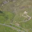
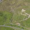
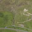
Aerial Photography (October 1973)
Oblique aerial photographs of Catpund settlement, Shetland, photographed by John Dewar in 1973.

