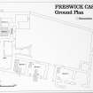
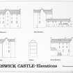
Accessibility

Font Size

100% 150% 200%

Background Colour

Default Contrast
Close Reset

Freswick Castle

Tower House (Medieval)

Site Name Freswick Castle

Classification Tower House (Medieval)

Alternative Name(s) Freswick House, Can 071-3; Castle Of Freswick

Canmore ID 9282

Site Number ND36NE 3
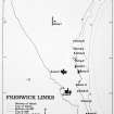
NGR ND 37801 67142

Datum OSGB36 - NGR

Permalink http://canmore.org.uk/site/9282

Ordnance Survey licence number AC0000807262. All rights reserved.
Canmore Disclaimer. © Bluesky International Limited 2025. Public Sector Viewing Terms

Toggle Aerial | View on large map

Digital Images

Oblique aerial view of Freswick Castle and bridge, looking E.
Oblique aerial view of Freswick Castle and bridge, looking E.Oblique aerial view of the castle, bridge, farmsteading and the remains of the mausoleum, dovecot and anti-tank blocks, taken from the SE.Oblique aerial view of the castle, bridge, farmsteading and the remains of the mausoleum, dovecot and anti-tank blocks, taken from the NE.Excavation photograph. Detail of trench. October 1979.View of castle and bridge. Collapse of outbuilding.Freswick Castle, ND36NE 3, Ordnance Survey index card, RectoFreswick Castle, ND36NE 3, Ordnance Survey index card, RectoGeneral viewView of gable of castle.Excavation photograph. View of trench. October 1979.General view of Castle and bridgeExcavation photograph. Cobbled surface. October 1979.Oblique aerial view of the castle, bridge, farmsteading and the remains of the mausoleum, dovecot and anti-tank blocks, taken from the SE.Oblique aerial view of the castle, bridge, farmsteading and the remains of the mausoleum, dovecot and anti-tank blocks, taken from the NE.Recorded finds of glass, bone, stone, clay and mortar. Glasgow Archaeological Journal, 
vol. 11 (1984), fig.11.Survey photograph. View of castle.Survey photograph. View of ruined wing.Survey photograph. View of castle.Fig. 12. Shoe leather.Aerial view showing the castle, bridge, mausoleum and dovecot at Freswick.View of derelict range. Detail of collapse.Freswick Castle, ND36NE 3, Ordnance Survey index card, page number 1, RectoView of courtyard and entrance stairway.Room 2. Detail of NW corner, oblique from SE.Aerial photograph of Freswick Castle, dovecot and mausoleum.Location maps of Freswick Castle. Glasgow Archaeological Journal, vol. 11 (1984), fig.1.Excavation photograph. Detail of trench. October 1979.Survey photograph. View of castle and mausoleum..View of courtyard and entrance stairway.FC W wing.Excavation photograph. Cobbled surface. October 1979.Freswick Castle, ND36NE 3, Ordnance Survey index card, RectoView of ruined wing.Selected pottery sherds. Glasgow Archaeological Journal, vol. 11 (1984), fig.13.Survey photograph. View of ruined wing.Survey photograph. View of castle and bridge.Survey photograph. View of derelict range.Freswick Castle: Basement Level Plan (2 negatives).  Copy in library.Trench plans.  The original ink drawings for this illustration came from DC 489, DC 492 & DC 497.Canisbay (East) MapOblique aerial view of Freswick castle, bridge, farmsteading and the remains of the mausoleum, dovecot and anti-tank blocks, taken from the E.Excavation photograph. View of trench. October 1979.Excavation photograph. Detail of trench. October 1979.Excavation photograph. View of trench. October 1979.Survey photograph. View of castle.Fig. 4. Ground plan.  Copy in library.  Original illustration based on pencil drawing DC 498.Fig. 7. Trench plans.  The original ink drawings for this illustration came from DC 496, DC 495, DC 493, DC 487 & DC 486.Excavation photograph. Cobbled surface. October 1979.Freswick Castle, ND36NE 3, Ordnance Survey index card, page number 2, VersoExcavation photograph. View of trench. October 1979.Oblique aerial view centred on Freswick Castle, taken from the SSE.Oblique aerial view of Freswick Castle and bridge, looking SSE.Oblique aerial view of Freswick Castle and bridge, looking ESE.Elevation/sections - north, west and east walls. Glasgow Archaeological Journal, vol. 11
(1984), fig.5.Recorded finds of metal. Glasgow Archaeological Journal, vol. 11 (1984), fig.10.Excavation photograph. View of trench. October 1979.Excavation photograph. Detail of trench. October 1979.View of gable of castle.Survey photograph. View of bridge.Survey photograph. Castle and mausoleum.Survey photograph. View of derelict range.Fig. 2. Location of Garden trenches.  Copy in library.Fig. 7. Section layer key.Film C/Negs 3 & 4General survey area plan.Oblique aerial view of the castle, bridge, farmsteading and the remains of the mausoleum, dovecot and anti-tank blocks, taken from the E.Freswick Castle, ND36NE 3, Ordnance Survey index card, page number 2, RectoView of mausoleum with castle in backgroundRoom 2. Detail of NW corner, oblique from SE.Oblique aerial view centred on Freswick Castle, taken from the ESE.Oblique aerial view of Freswick Castle and bridge, looking SW.Elevations. Glasgow Archaeological Journal, vol. 11 (1984), fig.3.Room 2. Detail of NW corner, oblique from SE.View of trench. October 1979.Excavation photograph. View of trench. October 1979.Survey photograph. View of castle and bridge.View of ruined wing.Fig. 6. Trench sections.  The original ink drawings for this illustration came from DC 467, DC 490 & DC 491.View of Castle elevationView of castle and bridge.View of bridge and castle from south westExcavation photograph. Detail of trench. October 1979.Oblique aerial view of Freswick Castle and bridge, looking NNE.

First 100 images shown. See the Collections panel (below) for a link to all digital images.

Administrative Areas

  • Council Highland
  • Parish Canisbay
  • Former Region Highland
  • Former District Caithness
  • Former County Caithness

Archaeology Notes

ND36NE 3 37801 67142

See also:

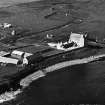
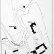
ND36NE 8 ND 3769 6708 Dovecot

ND36NE 9 ND 3774 6713 Mausoleum

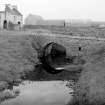
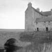
ND36NE 37 ND 37777 67120 Bridge

ND36NE 52.00 ND 37834 67064 Steading

ND36NE 52.01 ND c. 377 670 Proposed farmhouse

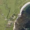
(ND 3780 6713) Freswick Castle (NAT)

OS 1:10,000 map, (1975).

Freswick House [NAT]

OS (GIS) AIB, April 2006.

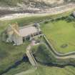
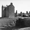
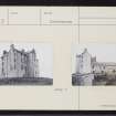
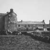
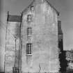
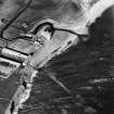
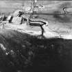
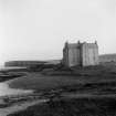
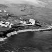
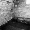
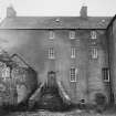
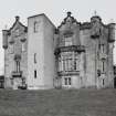
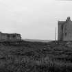
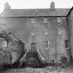
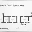
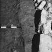
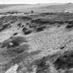
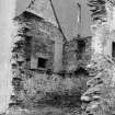
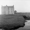
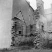
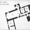
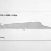
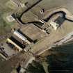
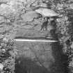
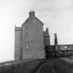
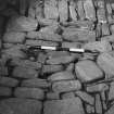
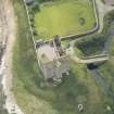
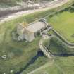
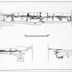
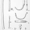
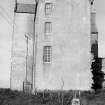
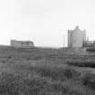
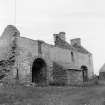
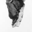
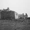
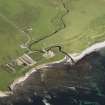
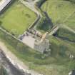
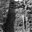
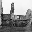
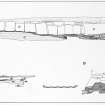
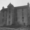
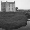
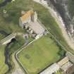
Freswick House is a tall tower-like building, probably of the early 17th century with 18th century additions, standing on a knoll and overlying an extension of the Freswick Links occupation site (ND36NE 4) characterised by a dense concentration of grass-tempered pottery in a midden layer, and possibly early structures, beneath the N part of the house (Morris, Batey and Rackham 1979).

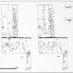
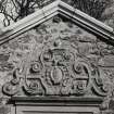
The main building, five storeys high, lies roughly E-W, with its stair-tower midway along the N front. A later wing projects S from the E end and contemporary offices from the W end. The walls are harled and the gables of the earlier structure are crow-stepped.

The house, built by the Mowats is mentioned as 'the manor place of Burnesyde with the mill' in 1653 (see (M) 1). In 1661 it passed to the Sinclairs, and by about 1725 it was known as the House of Freswick, as opposed to the Castle of Freswick, which name is applied to ND36NE 7. It appears to have retained this name until the modern house at ND 3762 6708 was built, when the name 'Freswick Castle' was applied to it.

The existence nearby of a beehive shaped dovecot (ND36NE 8), generally accepted as being a 16th century form, might indicate an earlier house at the site, but it is equally possible that it is simply late of its type.

Although uninhabited in 1962, the house was being maintained and in 1979 was being prepared for renovation.

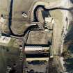
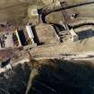
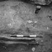
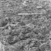
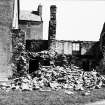
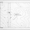
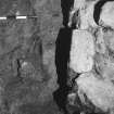
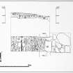
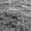
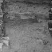
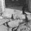
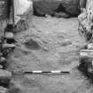
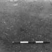
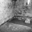
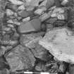
ND 3779 6712. A small-scale emergency excavation in 1979 in the gardens by Durham University revealed structural traces but no dating evidence. Substantial stone slabbing could represent croft remains or a farm building. It is now tree-covered.

Orig Paroch Scot 1955; J Macfarlane 1906-8; J Mowat 1931; N Tranter 1962-70; C Morris, C Batey and D Rackham 1979; C Batey 1982; Visited by OS (R D) 10 September 1962; HBD No. 6.

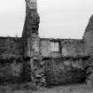
Freswick Castle is as described and illustrated by the previous authorities. It is still inhabited

Visited by OS (J B) 21 July 1982.

References

MyCanmore Image Contributions


Contribute an Image

MyCanmore Text Contributions