
Skirza


Mound (Period Unassigned)
Site Name Skirza
Classification Mound (Period Unassigned)
Alternative Name(s) Can 055
Canmore ID 9277
Site Number ND36NE 25
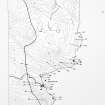
NGR ND 3856 6834
Datum OSGB36 - NGR
Permalink http://canmore.org.uk/site/9277


- Council Highland
- Parish Canisbay
- Former Region Highland
- Former District Caithness
- Former County Caithness
ND36NE 25 3856 6834.
ND 3855 6830. A grass-covered mound, 17 by 12m and about 1m high, possibly representing a structure. It has a telegraph post dug into it.
C E Batey 1982.
ND 3856 6834. An amorphous stony area as described, probably the remains of a structure as suggested, its original plan destroyed during cultivation.
Visited by OS (J B) 20 July 1982.
Project (1980 - 1982)
Field Visit (1982)
ND 3855 6830. A grass-covered mound, 17 by 12m and about 1m high, possibly representing a structure. It has a telegraph post dug into it.
C E Batey 1982.

