
Rowanburn


Bell Pit(S) (19th Century) - (20th Century), Colliery (19th Century) - (20th Century), Mine Workings (19th Century) - (20th Century)
Site Name Rowanburn
Classification Bell Pit(S) (19th Century) - (20th Century), Colliery (19th Century) - (20th Century), Mine Workings (19th Century) - (20th Century)
Alternative Name(s) Canonbie Colliery; Blinkbonny Colliery; Rowanburnhead
Canmore ID 92597
Site Number NY47NW 24
NGR NY 40868 77315
NGR Description Centred NY 4082 7733
Datum OSGB36 - NGR
Permalink http://canmore.org.uk/site/92597


- Council Dumfries And Galloway
- Parish Canonbie
- Former Region Dumfries And Galloway
- Former District Annandale And Eskdale
- Former County Dumfries-shire
Field Visit (28 April 1993)
NY47NW 24 centred 4082 7733
See also NY47NW 16 and 22.
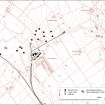
The mining remains that lie to the N and W of Rowanburn village (NY47NW 30) fall within the Canonbie coalfield, and date from the early 19th century until 1922, when the exhaustion of workable seams brought large-scale operations to a close. The remains comprise the spoil dumps, tramway connections and buildings of the Canonbie and Blinkbonny collieries, together with the demolished spoil dumps of some earlier mines. The rows of cottages in the village itself, each with its garden plot, are also of interest, having been built to accommodate the miners.
Although it is not known when mining operations first began in this area, the pattern of field boundaries shown on a map of the parish, produced for the Buccleuch estate in 1810, clearly overlie the spoil bing of one of the earlier mines. Further evidence of early mining is provided by the 1st edition of the OS 6-inch map (Dumfriesshire, sheet liv, 1862) which indicates the positions of two old shafts. Traces of both still survive, the one to the S of Rowanburnhead as a cleft in the N bank of the Rowan Burn (NY 4055 7767), while the other is marked by a spoil dump approached by a track from the SW (NY 4056 7731). A short distance to the NW, a large spoil dump with a dimpled surface stands proud in the middle of the field (NY 4052 7738). The remains of many more spoil dumps survive within the neighbouring fields, but successive years of ploughing have reduced them to low spread mounds.
By the publication date of the 1st ed of the OS map, Canonbie Colliery was in operation (NY 4082 7732), and was linked by a spur to the Langholm Branch of the North British Railway. Behind the village shop and the offices of Land Drive, on the N side of the road, the footings of a building and a concrete machinery base are visible; these are probably all that remain of the pit-head. A large mound of spoil lies immediately to the N, in an area which has recently been landscaped (NY 4086 7740). To the E, on the W side of the track to Rowanburnhead, there are two rectangular ponds which may be associated with the initial sorting of the coal (NY 4093 7739; NY 4096 7734). The brick-built weighing-house lies between the two ponds. One further building belonging to the colliery is situated in the NE corner of a field, some 450m to the SE of Rowanburnhead; this building is known locally as the powder store (NY 4094 7768). Neither the ponds, the weighing-house nor the powder store are shown on the 1st ed of the OS map, but all are depicted on the 2nd ed, published in 1900 (Dumfriesshire, Sheet liv, 1900).
By 1900, a second colliery had opened to the NE at Blinkbonny, and an inclined plane linked this back to Canonbie Colliery. The embankment of the inclined plane can still be followed across the fields, and the indentations left by the sleepers of the two parallel tram-lines are visible along its course. A thicket now extends across the site of Blinkbonny Colliery and the remains of its heavily-quarried spoil bing (NY 4125 7760).
Visited by RCAHMS (ARW, SPH), 28 April 1993.
SRO, GD 224/511/6/9-10; I Donnachie 1971.
Blinkbonny Colliery, Rowanburn: no. 1875 at NY 4125 7760.
Canonbie Colliery, Rowanburn: no. 1876 at NY 4082 7733.
Listed as mines.
RCAHMS 1997.

