
Pricing Change
New pricing for orders of material from this site will come into place shortly. Charges for supply of digital images, digitisation on demand, prints and licensing will be altered.
Ackergill, Quadrant Observation Tower


Observation Post (20th Century)
Site Name Ackergill, Quadrant Observation Tower
Classification Observation Post (20th Century)
Alternative Name(s) Sinclair's Bay Defences; Pillbox 1, Wic 131
Canmore ID 9218
Site Number ND35SW 52
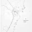
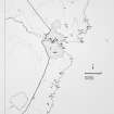
NGR ND 34912 54945
Datum OSGB36 - NGR
Permalink http://canmore.org.uk/site/9218


- Council Highland
- Parish Wick
- Former Region Highland
- Former District Caithness
- Former County Caithness
ND35SW 52 34912 54945
Formerly entered as ND35SE 79.
See also ND35SW 53.
A very damaged modern pill-box, with rubble strewn over the beach. The base is visible in section, 3 to 4m long.
C E Batey 1981.
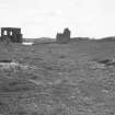
At the location given there is a quadrant observation tower. Situated in a field about 15m S from the coastal path. Constructed of brick and concrete the roofed observation platform stands on four square concrete columns.
A pillbox is at ND 3492 5497 (see ND35SW 53).
Visited by RCAHMS (DE, SW), August 2000.
REFERENCE
A very damaged modern pill-box, with rubble strewn over the beach. The base is visible in section, 3 to 4m long.
Batey 1981, No.131.

