
Clevigarth


Broch (Iron Age), Settlement (Iron Age)(Possible)
Site Name Clevigarth
Classification Broch (Iron Age), Settlement (Iron Age)(Possible)
Alternative Name(s) Kilder Brou; 'the Broken Brough'
Canmore ID 917
Site Number HU41SW 3
NGR HU 40718 12904
Datum OSGB36 - NGR
Permalink http://canmore.org.uk/site/917


- Council Shetland Islands
- Parish Dunrossness
- Former Region Shetland Islands Area
- Former District Shetland
- Former County Shetland
HU41SW 3 4072 1290
(HU 4070 1290) Brough (OE)
OS 6" map, Shetland, 2nd ed., (1903).
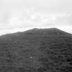
A broch, sometimes erroneously referred to as 'The Broken Brough', a name properly belonging to a mass of rock to the north.
The broch is now largely obscured by its own debris, which fills the interior and rises to about 10' or 12' on the outside. Although the entrance is not distinguishable the outer and inner faces of the wall can still be followed fairly well. These indicate an average thickness of some 14' and an over-all diameter of about 57' 6".
There are indications of out-buildings on the NW.
RCAHMS 1946, visited 1930.
A broch, generally as described and illustrated by RCAHMS. The entrance can be distinguished in the SW, and the majority of the outbuildings, visible as ground disturbance and upright slabs protruding through the turf, are also in the SW.
Surveyed at 1/2500.
Visited by OS (NKB) 23rd May 1968.
HU 407 129 Investigations at Clevigarth Broch were carried out as part of the Old Scatness/Jarlshof Environs Project. A geophysical survey of approximately 2.4ha was carried out to identify any anomalies that might represent midden accumulations and extramural settlement on the lower slopes of the broch mound. No substantial midden accumulations were positively identified. Anomalies suggesting slight midden accumulation were investigated by two soil pits on the lower slopes (apron) of the mound. Both of these were found to contain a shallow sequence of midden-rich sediments which were sampled. The small apron formed by the lower slope of the broch mound showed signs of ard cultivation.
The survey beyond the broch mound showed some correspondence to the visible field boundaries. Three test pits within the field system indicated the possibility of an anthropogenic soil to the N of the broch. The field system to the S, which may well have pre-dated the broch, gave no strong indications of anthropogenically enhanced cultivated soils. Thin section work will clarify the situation.
Sponsors: HS, BP Operating Company, European Union (European Agricultural Guidance and Guarantee Fund), SNH, Shetland Amenity Trust, Shetland Enterprise Company, Shetland Islands Council Charitable Trust, University of Bradford.
S J Dockrill, V E Turner, L D Brown 2003.
Field Visit (2 September 1930)
Broch, near Clevigarth. This broch is situated rather more than half a mile N.E. of the farm-buildings at North Exnaboe, a few paces from the edge of the shelving rocks which slope down to the W. side of the long narrow inlet known as Blo-geo or ‘the Blue Creek’. It is sometimes erroneously spoken of as ‘The Broken Brough’, a name properly belonging to a mass of rock that projects from the cliff a little way to the N. and is not unlike a castle toppling forward into the sea.
The building is now largely obscured by its own debris, which fills the interior and rises about 10 or 12 ft. on the outside. Although the entrance is not distinguishable, the outer and inner faces of the wall can still be followed fairly well. These indicate an average thickness of some 14 ft. and an over-all diameter of about 57 ft. 6 in. On the S.W. the process of dilapidation has exposed the upper parts of two cells; their entrances are covered up with debris, as is also an opening, the lintel of which can be seen on the inner face of the wall in the N.W. sector. On the same side are indications of ‘out-buildings’. The ‘geo’ in front would be an excellent natural harbour, and it could be easily reached from the broch.
RCAHMS 1946, visited 2 September 1930.
OS 6" map, Shetland, 2nd ed., (1903).
Measured Survey (1930)
The broch at Clevigarth was surveyed by RCAHMS in c.1930. The plan was redrawn in ink and published at a reduced scale (RCAHMS 1946 Fig. 488).
Aerial Photography (October 1973)
Oblique aerial photographs of Clevigarth broch, Shetland, photographed by John Dewar in 1973.
Publication Account (2002)
HU41 1 CLEVIGARTH
HU 407129
A probable broch in Dunrossness, on the shore of a rocky inlet. The wall faces are visible and indicate a thickness of about 14 ft.; the overall diameter is about 57.5 ft. so the wall proportion would be about 48.5%. The upper parts of two cells are apparent in the wall on the SW and the lintel of a door in the inside wall face on the north-west. There are traces of many out-buildings (Ill. 4.62).
Sources: 1. OS card HU 41 SW 3, inc. plan: 2. RCAHMS 1946, vol. 3, no. 1147, 27 and fig. 488 (plan).
E W MacKie 2002

