
Pricing Change
New pricing for orders of material from this site will come into place shortly. Charges for supply of digital images, digitisation on demand, prints and licensing will be altered.
Kirknewton Airfield


Airfield (20th Century)
Site Name Kirknewton Airfield
Classification Airfield (20th Century)
Canmore ID 91660
Site Number NT16NW 52
NGR NT 1249 6575
NGR Description Centred NT 1249 6575
Datum OSGB36 - NGR
Permalink http://canmore.org.uk/site/91660


- Council Edinburgh, City Of
- Parish Ratho
- Former Region Lothian
- Former District City Of Edinburgh
- Former County Midlothian
NT16NW 52.00 Centred 1249 6575
NT16NW 52.01 NT 114 650 Military Camp
NT16NW 52.02 NT 11757 65848 Aircraft Hangar
NT16NW 52.03 NT 11818 65791 Building
NT16NW 52.04 NT 11837 65842 and NT 11821 65874 Buildings
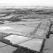
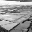
This airfield opened during late 1941, but by 1944 it is recorded as having no hangars. In more recent times three hangars were noted. The First Battalion, Gordon Highlanders now occupies one of the dispersal areas to the W.
The USAF used the airfield during the 1950s for storage, but it was returned to Britain during the later 1960s. In more recent years it has been used for a gliding school.
D J Smith 1983
Many buildings adjacent to the public road have now been removed.
J A Guy 1997; NMRS MS 810/5, 30-3.
Visible on Ordnance Survey aerial photograph 65/50/114.
Information from RCAHMS (RJCM) 6 January 1998
The airfield is visible on RAF WW II vertical air photographs (NLA 71, 3010-3025, 4010-4025, flown 9 September 1943), and shows one aircraft hangar, probably a Bellman type, in the same location as the present day. Several blister hangars are also visible around the airfield perimeter along with dispersal bays and other small buildings.
The military camp is also visible on the air photographs (NLA 71, 4010-4012, flown 9 September 1943).
No defensive pillboxes can be seen on the photographs, but the runways have been camouflaged.
Information from RCAHMS (DE), March 2005
Note (5 November 2021)
The Pillbox Study Group have recorded a number of Type B dispersal pens located around the perimeter track at NT 1262 6604, NT 1276 6593, NT 1293 6589, NT 1290 6545, NT 1278 6536 and NT 1269 6528 and two blast shelters at NT 1178 6576 and NT 1179 6574. Both the pens and blast shelters appear to have been removed and are not visible on recent vertical aerial photography.
Information from Pillbox Study Group and HES (AKK) 5 November 2021

