
Leanach Airfield


Airfield (20th Century)
Site Name Leanach Airfield
Classification Airfield (20th Century)
Canmore ID 91608
Site Number NH74NE 58
NGR NH 7552 4552
NGR Description Centred NH 7552 4552
Datum OSGB36 - NGR
Permalink http://canmore.org.uk/site/91608


- Council Highland
- Parish Croy And Dalcross (Inverness)
- Former Region Highland
- Former District Inverness
- Former County Inverness-shire
NH74NE 58 centred 7552 4552
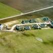
A pre-war Emergency Landing Ground only one building can be seen at the site.
D J Smith 1983.
The emergency landing ground is visible on RAF vertical air photographs (106G/Scot/UK169, 2011-2012, flown 26 August 1946), in fields between what is now Newlands of Culloden and Leanach. The air photographs show that the field boundaries had been removed within this area and according to the current OS digital 1:2500 scale map have now been replaced.
Buildings possibly connected with the landing ground are noted at NH 75655 45106; and at what is now the Culloden Moor Hotel NH 74912 45215, several huts are visible around a a flat roofed building.
Information from RCAHMS (DE), October 2004

