
Pricing Change
New pricing for orders of material from this site will come into place shortly. Charges for supply of digital images, digitisation on demand, prints and licensing will be altered.
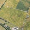
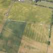
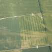
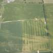
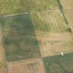
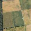
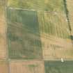
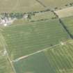
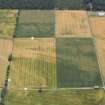
Kirkton Airfield


Airfield (20th Century), Pit(S) (Period Unassigned), Rig And Furrow (Medieval) - (Post Medieval)
Site Name Kirkton Airfield
Classification Airfield (20th Century), Pit(S) (Period Unassigned), Rig And Furrow (Medieval) - (Post Medieval)
Canmore ID 91607
Site Number NH89NW 27
NGR NH 8000 9816
NGR Description Centred NH 8000 9816
Datum OSGB36 - NGR
Permalink http://canmore.org.uk/site/91607


- Council Highland
- Parish Golspie
- Former Region Highland
- Former District Sutherland
- Former County Sutherland
NH89NW 27 centred 8000 9816
Part of this airfield falls on map sheet NH79NE
A Satellite Landing Ground (SLG), an old watch office bungalow and a few buildings survive with concrete bases.
D J Smith 1983
This grass airfield is situated on the S side of the A9 (T), two miles W of Golspie. Only a few small buildings are extant and in very poor condition. The watch house (bungalow) described by Smith (Smith 1983) has now been demolished and a new house built on the site.
J Guy 2000; NMRS MS 810/10, Vol.2, 92
The extreme E part of this Satellite Landing Ground is visible on wartime RAF vertical air photographs (NLA 33, 2.26-2.27, flown 11 April 1942). Dispersed aircraft are noted in fields to the NW and SW of a modern house annotated 'Kilmaree' (NH 79916 98328) on the OS Explorer 1:25000 scale map and the E end of the grass runway.
Information from RCAHMS (DE), February 2003

