
Pricing Change
New pricing for orders of material from this site will come into place shortly. Charges for supply of digital images, digitisation on demand, prints and licensing will be altered.
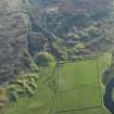
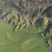
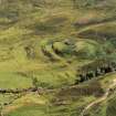
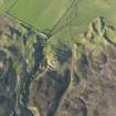
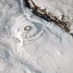
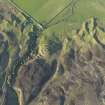
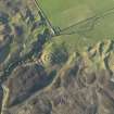
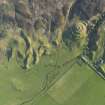
Kilbraur


Rig And Furrow (Medieval) - (Post Medieval), Township (Period Unassigned)
Site Name Kilbraur
Classification Rig And Furrow (Medieval) - (Post Medieval), Township (Period Unassigned)
Alternative Name(s) Kilbrare
Canmore ID 91447
Site Number NC80NW 25
NGR NC 825 098
NGR Description centred on NC 825 098
Datum OSGB36 - NGR
Permalink http://canmore.org.uk/site/91447


- Council Highland
- Parish Clyne
- Former Region Highland
- Former District Sutherland
- Former County Sutherland
Note
A township comprising two roofed and one unroofed building and eight enclosures is depicted on the 1st edition of the OS 6-inch map (Sutherland 1879, sheet xcvii). One roofed and ten unroofed buildings and eight enclosures are shown on the current edition of the OS 1:10560 map (1969).
Information from RCAHMS (SAH) 1 November 1995

