
Pricing Change
New pricing for orders of material from this site will come into place shortly. Charges for supply of digital images, digitisation on demand, prints and licensing will be altered.
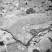
Little Rogart


Structure (19th Century)
Site Name Little Rogart
Classification Structure (19th Century)
Canmore ID 91294
Site Number NC70SW 91
NGR NC 7293 0393
Datum OSGB36 - NGR
Permalink http://canmore.org.uk/site/91294

- Council Highland
- Parish Rogart
- Former Region Highland
- Former District Sutherland
- Former County Sutherland
Note (26 January 1996)
NC70SW 91 7293 0393
A single unroofed structure is depicted on the 1st edition of the OS 6-inch map (Sutherland 1879, sheet civ), but it is not shown on the current edition of the OS 1:10000 map (1971).
Information from RCAHMS (AKK) 26 January 1996.
Aerial Photographic Interpretation (8 February 1999)
Oblique aerial photographs (RCAHMSAP 1995) show the remains of a single unroofed structure, approximately 500m NE of Reidchalmai farmsteading.
Information from RCAHMS (KJ) 8 February 1999.

