
Pricing Change
New pricing for orders of material from this site will come into place shortly. Charges for supply of digital images, digitisation on demand, prints and licensing will be altered.
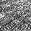
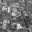
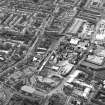
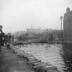
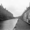
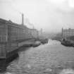
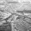
Edinburgh, Union Canal


Canal (Period Unassigned)
Site Name Edinburgh, Union Canal
Classification Canal (Period Unassigned)
Alternative Name(s) Edinburgh And Glasgow Union Canal
Canmore ID 91034
Site Number NT27SW 83
NGR NT 2291 7103
NGR Description From NT 2000 7011 to NT 2476 7309
Datum OSGB36 - NGR
Permalink http://canmore.org.uk/site/91034


First 100 images shown. See the Collections panel (below) for a link to all digital images.
- Council Edinburgh, City Of
- Parish Edinburgh (Edinburgh, City Of)
- Former Region Lothian
- Former District City Of Edinburgh
- Former County Midlothian
NT27SW 83.00 LIN 18 2000 7011 to 2476 7309.
(Continued from NT17SE 81.00)
NT27SW 83.01 NT 2476 7311 Canal Basin
NT27SW 83.02 NT 240 724 Canal
NT27SW 83.03 NT 20598 70219 Drumbryden Road Bridge
NT27SW 83.04 NT 23112 71154 and NT 23100 71145 Meggetland Road Bridges (Bridge No. 4)
NT27SW 83.05 NT 2464 7308 Canal Basin
NT27SW 83.06 NT 2466 7277 Canal; Bridge
NT27SW 83.07 NT 2122 7033 Kingsnowe Railway Bridge
NT27SW 83.08 NT 2463 7285 Warehouse (Possible)
NT27SW 83.09 NT 23995 72409 Walker Bridge
NT27SW 83.10 NT 23611 71893 Harrison Road Bridge
NT27SW 83.11 NT 2345 7161 Road Bridge
NT27SW 83.12 NT 2261 7086 Road Bridge
NT27SW 83.13 NT 2463 7282 Canal Basin
See also
NT27SW 3149 NT 21030 70284 Kingsknowe Road Bridge (Number 5) - Demolished/Replaced
NT27SW 3151 NT 20443 70124 Drumbryden Bridge (Number 6) - Demolished
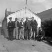
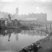
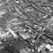
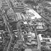
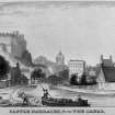
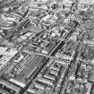
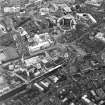
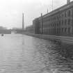
The original terminus of the canal was at Port Hopetoun (NT27SW 83.01), a large basin situated next to Lothian Road. Another basin, Port Hamilton (NT27SW 83.05), was built later as traffic grew heavy. As well as passengers there was an important passage into the city of coal, grain and building materials, although only waste was exported from the city via the canal. However, as trade declined, the area degenerated and Port Hopetoun and Port Hamilton were closed. A new terminus was created at Lochrin Basin (NT27SW 83.06), on an offshoot of the main canal which served Haig's Distillery.
G Hutton 1993.
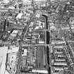
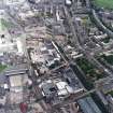
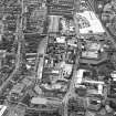
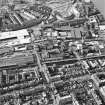
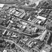
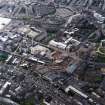
The course of the Union Canal passes under part of Wester Hailes housing scheme, emerging by the side of Dumbryden Road, at NT 2061 7022. From there, its level course continues NE to Fountainbridge, at NT 2463 7285. Its last 300m, and original terminus, Port Hopetoun (NT27SW 83.01) has been filled in and built over.
See LIN 18 general record for dates and details of construction)
Information from RCAHMS (IF) March 1996
A cinema building now stands on the site of Port Hopetoun (NT27SW 83.01), and Lochrin Basin (NT27SW 83.06) has also vanished under later developments. However, the present end of the canal is close to the former Lochrin Basin and this piece of canal is utilised by canoeists. The canal heads generally in a SW direction, along a contour line. It ends abruptly in the Wester Hailes area, where it has been culverted for over a mile.
H Brown 1997.
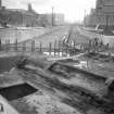
NT 19 70; NT 20 70 A watching brief was carried out in October 1998 while two slit trenches and a trial pit were dug on the line of the canal. The canal was infilled in the 1960s.
In slit trench 1 (NT 1948 7002), the profile of the canal was visible, while in slit trench 2 (NT 1954 7004), and the trial pit (NT 1906 7000), the canal appears to have been disturbed during its infilling, and only traces of the silt at its bottom, on the clay lining, were found. The fill material was of earth and building site waste.
Kirkdale Archaeology carried out a watching brief in March 1999 while four trial pits were dug along the line of the infilled canal. The evidence from the trial pits indicated that the canal was seriously disturbed during the infilling process in the 1960s.
Sponsor: British Waterways.
G J Douglas 1999.
(Scheduling number 11097). The length of the [Edinburgh and Glasgow] Union Canal between Fountainbridge [Edinburgh] and the River Almond [NT 1043 7063 to NT 2464 7785] has been accorded statutory protection by scheduling. The 15km long stretch comprises that portion of the canal within the former boundary of Midlothian.
[Extends onto NT17SW 97.00 and NT17SE 81.00].
Information from Historic Scotland, scheduling document dated 15 December 2003.
Watching Brief (13 September 2016 - 14 February 2017)
Headland Archaeology was commissioned by Scottish Canals and Mackenzie Construction Ltd (the client) to monitor vegetation removal works and the recording of the canal wall prior to the construction of a piled wall and canal mooring along the Union Canal.
Information from Rafael Maya-Torcelly (Headland Archaeology), February 2017.
OASIS ID: headland1-276563
Archaeological Evaluation (8 May 2017 - 21 August 2017)
NT 24255 72556 A programme of archaeological work was undertaken, May 2017, prior to a residential development at 9–11 Horne Terrace. The removal of a floor slab revealed a circular cobbled area to the NE of the development area, possibly associated with the use of the building as a blacksmiths. Monitoring within the scheduled area of the Union Canal recorded the original wooden canal lining and the wooden planks of an old slipway.
Archive: NRHE (intended)
Funder: AMA (Majestic) Ltd
Information from Kevin Paton and Anne-Aymonne Marot (AOC Archaeology Group) 26 September 2017. OASIS ID - aocarcha1-296494

