
Borrowston


Broch (Iron Age)(Possible)
Site Name Borrowston
Classification Broch (Iron Age)(Possible)
Alternative Name(s) Wic 196
Canmore ID 9090
Site Number ND34SW 8
NGR ND 32881 43536
Datum OSGB36 - NGR
Permalink http://canmore.org.uk/site/9090


- Council Highland
- Parish Wick
- Former Region Highland
- Former District Caithness
- Former County Caithness
ND34SW 8 32881 43536.
(ND 3288 4353) Broch (NR)
(remains of)
OS 1:10,000 map, (1976)
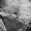
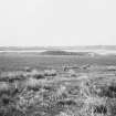
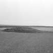
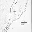
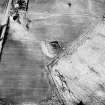
A grass-covered mound, 114ft in diameter and about 10ft high containing the remains of a broch. The upper portion, which is circular, 42ft in diameter and 3ft high, probably indicates the position of the main structure. At the W end of the mound, and some 6ft above the natural level, there is a well-marked terrace in the form of a crescent, some 20ft in maximum width from the base of the more elevated portion. There are no signs of excavation.
RCAHMS 1911.
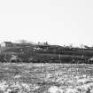
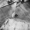
As described by the RCAHMS. Slight mutilation on the S side of the broch has revealed some stonework, typical of broch structure.
Resurveyed at 1:2500.
Visited by OS (R L) 18 April 1967.
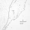
The remains of this broch have been reduced to a large grass-grown mound situated at the edge of a cultivated field 240m S of Borrowston farmsteading (ND 3291 4381). The main body of the mound measures 35m in diameter by 2.5m in height, but what is probably the position of the broch is marked by a mound measuring 13.5m from NE to SW by 12m transversely and up to 1.2m in height, which rises from its flat top a little W of its centre. A small, probably modern, pit measuring 1m in diameter and 0.5m in depth, has been dug into the upper mound. What may be the remains of a building are situated immediately to the E of the upper mound, where there is a shallow depression about 8m in length. In a corresponding position immediately to the W of the broch the surface of the mound has been heavily disturbed.
(YARROWS04 688)
Visited by RCAHMS (JRS) 12 August 2004
Scheduled as 'Borrowston... the remains of a broch'.
Information from Historic Scotland, scheduling document dated 25 October 2005.
Publication Account (2007)
ND34 1 BORROWSTON ND/3288 4353
Possible broch in Wick, Caithness, consisting of a grass-covered mound with several steps or tiers, 34.8m (114ft) in diameter and 3m (10ft) high overall. There are two clear tiers, the upper part presumably being the broch mound itself which rests on a flat-topped platform and which thus has a terrace round it [1, 2]. A more recent survey detected four, perhaps five, steps in the mound and cast doubt on whether any of these was a ruined broch [3].
Sources: 1. NMRS site no. ND 34 SW 8: 2. RCAHMS 1911b, 152, no. 510: 3. Mercer 1985, 105, no. WAR 232, fig. 65.
E W MacKie 2007

