
Pricing Change
New pricing for orders of material from this site will come into place shortly. Charges for supply of digital images, digitisation on demand, prints and licensing will be altered.
Warehouse, West


Cairn (Bronze Age), Marker Cairn(S) (Modern)
Site Name Warehouse, West
Classification Cairn (Bronze Age), Marker Cairn(S) (Modern)
Alternative Name(s) Cairns Of Warehouse
Canmore ID 9081
Site Number ND34SW 71
NGR ND 30507 42107
Datum OSGB36 - NGR
Permalink http://canmore.org.uk/site/9081


- Council Highland
- Parish Wick
- Former Region Highland
- Former District Caithness
- Former County Caithness
ND34SW 71 30507 42107.
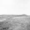
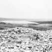
An Orkney-Cromarty type round cairn with a Camster-type chamber. One of a group of five cairns known as Cairns of Warehouse, it was excavated by Rhind in 1853 and Anderson in 1865, prior to Rhind's excavation it had been used as an illicit still. It surmounts a conspicuous natural mound and is now completely ruined, but at the time of Anderson's excavation it was about 9ft high and 30 to 40ft in diameter. His plan shows part of an encircling wall face on either side of the entrance.
J Rhind 1854; J Anderson 1886; A S Henshall 1963.
This cairn is not chambered. Description of excavations given by Henshall in 1963 should have been applied to McCole's Castle (ND34SW 40).
J L Davidson and A S Henshall 1991.
Scheduled with ND34SW 41, ND34SW 69, ND34SW 70 as Cairns of Warehouse.
Information from Historic Scotland, scheduling document dated 9 November 2000.
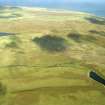
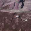
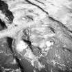
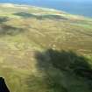
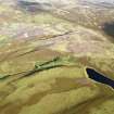
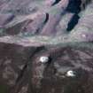
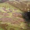
This large cairn crowns the summit of a heather-clad knoll on the highest point of the watershed between the Burn of Warehouse to the SSW and Loch of Yarrows to the NNE. It comprises a mass of rubble measuring 21.7m from NE to SW by 17.4m transversely and up to 3m in height on the S. It has been extensively robbed and, in addition to the large, deep hollow at its centre, its surface is marked by several shallow depressions and small heaps of gathered stone. Two modern marker cairns have been erected on the cairn. That on the NW measures 1.3m in diameter and 1.35 in height, while that on the SE measures 1.7m in diameter and stands 2.8m in height.
(YARROWS04 418)
Visited by RCAHMS (ARG) 28 July 2004
Excavation (16 September 2013 - 8 October 2013)
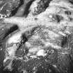
ND 30542 42102 A programme of excavation was undertaken, 16 September – 8 October 2013, at the southern end of the Yarrows trail – Warehouse West and Warehouse South. Both cairns had been excavated previously during the 19th century with a central cist found within Warehouse West and a chambered cairn revealed at Warehouse South. The excavations confirmed the presence of a central cist at Warehouse West and showed that it is most likely a Bronze Age cairn as there are no structured walls created to form the cairn. The excavations of Warehouse South re-excavated the central chamber of the cairn as well as revealing part of the outer façade. The excavations confirmed that the cairn is not a simple round cairn, but is in fact a highly denuded long cairn with horn works revealed at the entrance and at the end of the tail. All excavations were backfilled to ensure the consolidation of the cairns and to allow for an easier interpretation of the cairns by visitors to the sites.
Archive: NRHE
Funder: Npower
John Barber, Alan Duffy and Kevin Paton – AOC Archaeology Group
(Source: DES, Volume 18)

